
It is probably the most frequently watched instrument on board after the compass, and yet one of the worst configured. The depth sounder shows a number, the number is reassuring, and most crews never stop to ask what exactly that number measures. Between "2.5 metres under the transducer" and "2.5 metres under the keel" lies the thickness of a boatyard invoice.
This guide starts from the beginning: how a sounder produces its reading, how to set the offset once and for all, how to interpret the nature of the seabed from the echo, and above all when the displayed value should not be trusted.
How a depth sounder works
The principle fits in one sentence: a transducer bonded under the hull emits a sound pulse downwards, then measures the time the echo takes to return. Since sound travels through seawater at roughly 1,500 metres per second, a 10-millisecond round trip corresponds to 15 metres of travel. The unit halves that and displays 7.5 m.
Two transducer parameters govern everything else:
- Frequency. Leisure sounders usually work at 200 kHz, sometimes 50 kHz. High frequency gives a narrow beam and a sharp picture but less range; low frequency opens a wide cone and reaches great depths, at the cost of detail.
- Cone angle. The beam is not a laser but a cone of 10 to 20 degrees. Over 30 metres of water that cone illuminates a disc several metres across. The sounder then displays the closest point found inside the cone — not necessarily the depth directly under your keel.
That last subtlety has an important practical consequence: over broken ground the sounder errs on the safe side, warning you about the rock before you are actually over it. Good news overall, but it also explains the abrupt jumps in readings along a steep drop-off.
Setting the offset: the central question
A sounder always measures the distance between the transducer and the seabed. Everything else is a convention, controlled by a setting called offset (or "keel offset" depending on the brand).
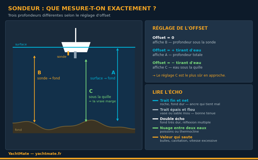
The three possible conventions
- Zero offset. The unit shows the raw distance between transducer and seabed. This is the factory setting and the most misleading one: the transducer usually sits 40 to 60 cm below the waterline, while the keel goes much deeper.
- Positive offset, equal to the transducer depth. The display then matches total depth, from surface to seabed — the value comparable to the soundings printed on the chart, handy for cross-checking a position.
- Negative offset, equal to the transducer-to-keel distance. The unit shows the water actually available under the lowest point of the boat. This is the safest setting when approaching or anchoring: when it reads 0.5 m, you have 50 cm and nothing more.
Whichever convention you choose, write it in permanent marker next to the display: "under keel" or "surface". On a shared boat, a charter or with rotating crew, this single precaution prevents more groundings than any other. A number without a convention is not information.
Measuring your offset properly
The most reliable method is to measure ashore with the boat on the hard: tape measure from the bottom of the keel to the centre of the transducer. Afloat, you can approximate by lowering a hand lead alongside the hull, or by comparing the sounder reading with a manual sounding in calm water over flat ground. Record the result in the logbook: it is a boat characteristic, just like air draught.
Read the echo, not just the number
Graphic sounders display a scrolling trace that carries far more information than the bare figure. Learning to read it turns the instrument into a genuine seabed survey tool.
- A thin, sharp, dark line means hard ground: rock, slab, compacted gravel. An anchor holds poorly there and may drag or become trapped.
- A thick, diffuse line indicates soft ground: mud, fine sand, sediment. The signal penetrates the surface layer before returning. Generally good news for anchor holding.
- A double echo, a second line at twice the depth, points to a highly reflective, usually rocky bottom, where the signal bounces twice between seabed and surface.
- A cloud in midwater corresponds to fish shoals, plankton, or a thermocline — an abrupt temperature change that reflects part of the signal.
- Weed beds appear as a fuzzy, irregular fringe just above hard ground. In the Mediterranean this signature often means posidonia, where anchoring is prohibited.
When not to trust your sounder
The sounder is a robust instrument, but several situations produce false readings — sometimes dangerously reassuring ones.
Losing the bottom at speed
Under power or on a fast reach, bubbles from the bow and propeller sweep under the hull and scatter the beam. The sounder then jumps around, or loses the bottom entirely. If the reading turns erratic during an approach, slow down: you improve the measurement and buy yourself margin at the same time.
The phantom bottom
In heavily laden water, or across a marked thermocline, the sounder may lock onto an intermediate layer and show a depth far shallower than reality. Conversely, over very soft mud the signal can pass through tens of centimetres of sediment and overstate the usable water.
The tidal offset
The sounder measures the present moment, not the situation two hours from now. On the Channel and Atlantic coasts, a comfortable 3-metre reading at high water can become a guaranteed grounding at low water. Every anchoring decision means combining the sounder reading with the predicted height of water at the lowest point of your stay.
Always set the shallow alarm at a value that gives you time to react, not at your minimum margin. On a boat drawing 1.80 m at 6 knots, an alarm at 2.50 m leaves only seconds. An alarm at 5 metres during a coastal approach is far more useful — and a second, deep-water alarm will warn you if you drift off the anchoring plateau overnight.
Using the sounder as a navigation instrument
Beyond immediate safety, the sounding is a position-fixing tool in its own right — the oldest navigation aid after the compass.
The check sounding
By following a depth contour drawn on the chart, you obtain a line of position. Crossed with a bearing, it gives a perfectly usable fix. In fog, running along the 20-metre contour is a classic and safe way to follow a coast you cannot see.
Landfall recognition
The sequence of depths recorded at regular intervals during an approach forms a signature. Compared with the chart profile, it confirms — or disproves — that you really are in the channel you think you are following. It is a check entirely independent of GPS, and priceless the day the electronics return something doubtful.
Anchor watch
At anchor, the measured depth is used to calculate the scope to veer: three to five times the total height of water including tide, measured from the bow roller rather than from the transducer. Remember to add the freeboard before doing the maths.
Maintenance: five minutes per season
A transducer is a passive sensor, but it lives underwater. A few habits keep it reliable:
- Clean the active face at every haul-out. A layer of fouling or thick antifouling strongly attenuates the signal. Use only transducer-compatible antifouling, applied thinly.
- Check the through-hull and its seal. It is a hole below the waterline and deserves the same annual inspection as the others.
- Inspect the cable and connector. Corrosion at a bilge connector is the most common cause of intermittent signal loss.
- On a tilting through-hull transducer, check it is still vertical: an angled transducer measures a slant range and understates the true depth.
In summary
The sounder only becomes a safety instrument once you know exactly what it measures. A documented offset, an alarm calibrated to give reaction time, and a reading cross-checked against tide and chart: three habits that take an hour to set up and prevent most groundings.
The displayed figure is never a depth: it is a distance between a sensor and an echo. The whole skill lies in knowing what sits between the two.
To go further, our guides on tides and currents, anchoring and reading nautical charts are a useful complement.
Sail with more confidence using YachtMate
Charts, tides, marine weather and route tracking: everything you need to cross-check your sounder reading against reality.
Download YachtMate for free