Tides are one of the most fascinating — and sometimes most formidable — realities of coastal sailing. For a recreational boater, knowing how to read a tide table, understand the day's coefficient, or anticipate a flood current can make all the difference: between a smooth harbour entry and an embarrassing grounding, between a fast passage and hours of battling the tide. This guide covers everything you need to know to master tides and currents, in a practical and concrete way.
Why Do Tides Exist?
Tides are caused by the combined gravitational pull of the Moon and the Sun on the ocean's water masses. The Moon, although much smaller than the Sun, is so close to Earth that it exerts the dominant influence — roughly 2.2 times that of the Sun on tidal behaviour.
In practice, the Moon "pulls" water on the Earth-Moon side (creating a water bulge, the high tide) and centrifugal force from the Earth-Moon rotation creates a second bulge on the opposite side. As a result, most coastlines experience two high tides and two low tides per day — the so-called semi-diurnal regime. Some areas, like the Gulf of Mexico, have a diurnal regime (one tide per day) due to local geography.
Lunar Cycles and Tidal Range
The tidal range is the difference in height between high water and low water. It varies considerably depending on the Moon's position relative to the Sun:
- Spring tides: Moon and Sun are aligned (new Moon or full Moon). Tides are stronger, tidal range is maximum.
- Neap tides: Moon and Sun are at quadrature (first or last quarter). Tides are weaker, tidal range is minimum.
France's Atlantic coast and the English Channel are among the most extreme tidal environments in the world. The Bay of Mont-Saint-Michel holds the European record with tidal ranges exceeding 14 metres during extreme spring tides. By contrast, in the Mediterranean, tidal ranges rarely exceed 30 to 50 centimetres.
YachtMate integrates tidal data for your port and displays the available water depth at anchor or alongside in real time. No more juggling a paper tide almanac and a calculator — the app does the maths based on your vessel's draught.
The Tide Coefficient: What Is It For?
The tide coefficient is a number between 20 (extreme neap) and 120 (exceptional spring), indicating the amplitude of the day's tide relative to a reference tide. In France, it is published annually in the Almanach du marin breton, by the SHOM (French Naval Hydrographic and Oceanographic Service) and by many nautical apps.
How to Interpret the Coefficient
- 20 to 45: Neap tides — small range, limited currents. Ideal for entering shallow ports.
- 45 to 70: Average tides — intermediate situation, common at the start or end of a lunar cycle.
- 70 to 95: Spring tides — large range, strong tidal streams. Extra care needed in channels and passes.
- 95 to 120: Extreme spring tides — maximum phenomena, violent currents. Avoid certain passages or plan meticulously.
A coefficient of 95 does not mean the sea will be rough, but that the tidal range will be large and tidal streams very powerful. In fine weather, big spring tides can actually simplify certain manoeuvres if you anticipate them properly.
The Rule of Twelfths: Calculating Water Depth at Any Time
It would be convenient if the sea rose and fell uniformly. In reality, the tide follows an S-curve: slow at the beginning and end of the cycle, fast in the middle. The rule of twelfths allows you to quickly calculate the water depth at any moment between high water and low water.
Dividing the duration between two slack waters into 6 equal periods, the tidal range is distributed as follows:
- 1st hour: 1/12 of total range
- 2nd hour: 2/12 of total range
- 3rd hour: 3/12 of total range
- 4th hour: 3/12 of total range
- 5th hour: 2/12 of total range
- 6th hour: 1/12 of total range
Concrete example: High water at 10:00 at 5.80 m, low water at 16:00 at 1.00 m. Tidal range is 4.80 m. At 13:00 (3 hours after HW), depth will be approximately: 5.80 − (1/12 + 2/12 + 3/12) × 4.80 = 5.80 − 2.40 = 3.40 m.
With YachtMate, you don't need to do this calculation by hand. The app automatically generates the tide curve for any port on your itinerary and tells you whether your draught is compatible with a passage or berth at the planned time — a real time-saver when planning passages.
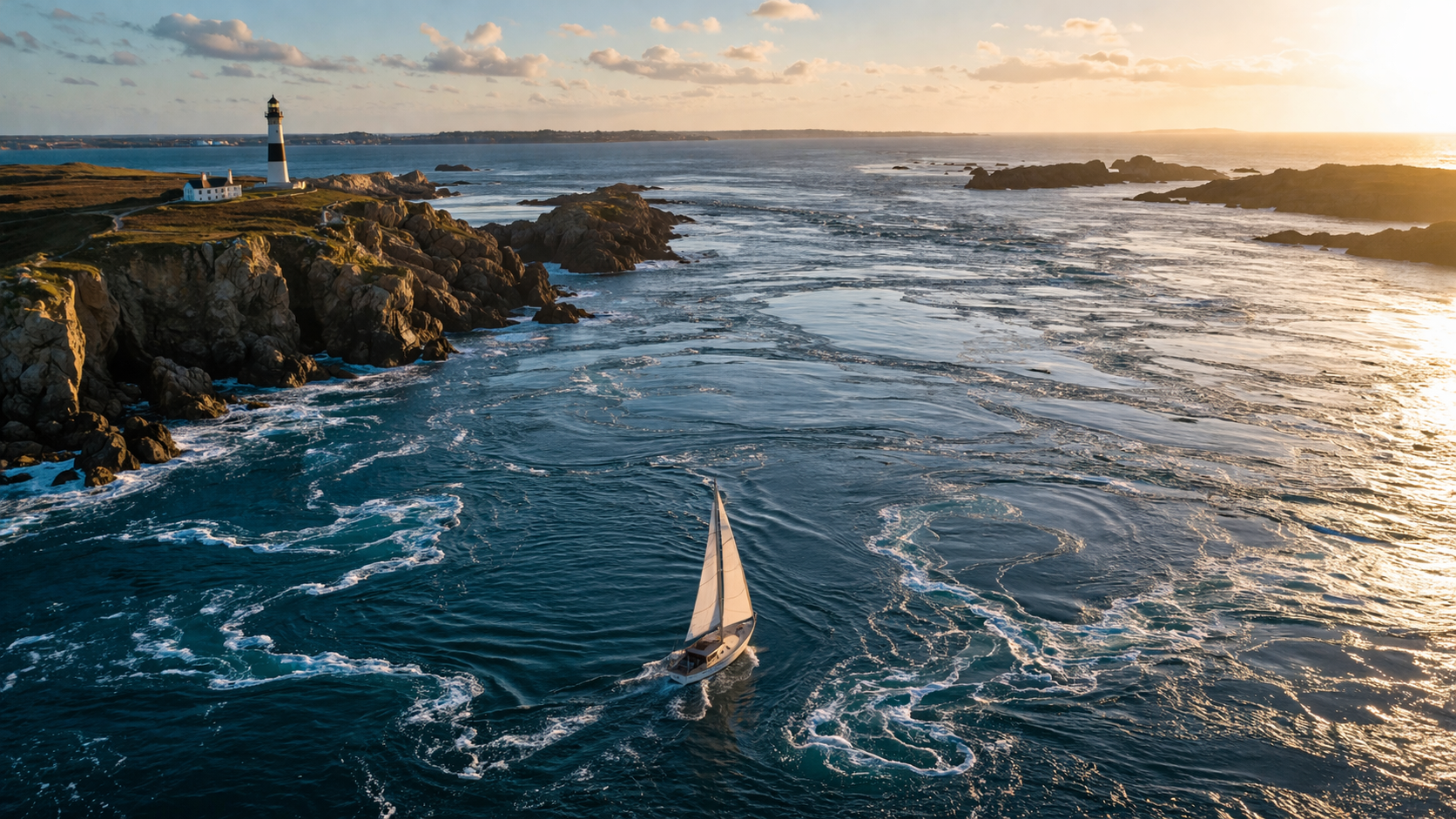
Tidal Streams: Flood, Ebb and Slack Water
The movement of water linked to tides generates tidal streams. These must not be confused with weather-driven currents (caused by wind) or permanent ocean currents (like the Gulf Stream). Tidal streams are cyclical, predictable, and can be very intense in large tidal range areas.
The Phases of a Tidal Stream
- The flood: current flowing towards the shore (or "incoming"), which generally sets with the start of the rising tide.
- The ebb: current flowing offshore (or "outgoing"), which sets with the falling tide.
- Slack water: the brief period of near-stillness between flood and ebb. This is often the best time to navigate a difficult passage. Note: slack water does not necessarily coincide with high water or low water — it can occur up to 3 hours before or after, depending on local geography.
Strong Current Areas in France to Know
Certain areas are known for particularly intense tidal streams. Sailors must respect them and plan carefully:
- Raz de Sein (Finistère): up to 7 knots at spring tides. Only attempt at slack water and in fair weather.
- Fromveur (Ouessant): 8 to 9 knots at extreme springs. Tricky and frequently rough passage.
- Raz Blanchard (Normandy): between Cap de la Hague and the Channel Islands, streams up to 10 knots.
- Breton passages: Passage du Four, Passage de la Teignouse — 4 to 6 knot streams to watch carefully.
- Gironde and Loire estuaries: strong ebb currents during floods combined with the tide.
In the Mediterranean, tidal streams are almost non-existent due to the small tidal range. This does not mean there are no currents — currents driven by density differences, wind and geographic configurations can be very strong (Strait of Bonifacio, Ligurian-Provençal current…).
Using Tides in Practice
Planning Your Departure and Arrival
The golden rule is to never enter or leave a port with a limited draught without first checking the available water depth. In Brittany and Normandy, many drying harbours (Audierne, Erquy, Le Palais…) are only accessible within 2 to 3 hours around high water. Forgetting this can mean a 10 to 12 hour wait.
To plan effectively:
- Consult the tide almanac for the nearest reference port.
- Calculate the water depth at the planned arrival time (rule of twelfths or software).
- Verify that this depth exceeds your draught by at least 0.5 m safety margin.
- Take the day's coefficient into account to assess current strength along your route.
Using Currents to Save Fuel
A favourable 2-knot current over a 30-mile passage can save you an hour of sailing — and therefore fuel. Conversely, leaving against a 3-knot tidal stream on a boat making 5 knots means you're only doing 2 knots over the ground: exhaustion and frustration await.
The strategy is to align favourable tidal streams with your route. In Brittany, for example, leaving Brest eastward at the start of the flood allows you to benefit from the fair current through the Rade and the Crozon Peninsula. Make it a habit to consult tidal stream atlases before every trip in strong tidal areas.
YachtMate's route planning feature lets you visualise tidal streams hour by hour along your itinerary. By simply adjusting your departure time, you can identify the optimal window to benefit from a fair tidal stream for most of your passage — which can radically change your ETA and fuel consumption.
Anchoring and Tides: Essential Precautions
Anchoring in large tidal range areas requires specific precautions that Mediterranean sailors often discover to their cost on their first Atlantic trip.
Calculating Chain Length
The basic rule is to lay 4 to 7 times the maximum water depth (high water + height at high water) in chain to ensure good holding. At spring tides with a 6 m range in 3 m of water at low tide, you'll have 9 m at high water: plan for at least 36 to 63 m of chain.
Swinging with the Tide
In areas with strong tidal streams, your boat will regularly swing around when the current reverses from flood to ebb. If several boats anchor in the same area with different chain lengths or different hull forms (sailing vs. motor), their swing radii will differ and collisions are possible. Watch how neighbouring boats are lying at anchor and adjust your position accordingly.
Essential Tools for Tides
Several resources give access to tidal information:
- SHOM (shom.fr) publishes official tide tables for France, available in print and digital form. The absolute reference.
- Nautical mobile apps like YachtMate integrate SHOM data so you can check times and heights at a glance, even offline.
- Tidal stream atlases (SHOM 563 for the Channel, SHOM 560 for the Atlantic) give hourly currents as charts: essential for navigating in large tidal range areas.
- VHF and radio services: CROSS Jobourg, CROSS Corsen and CROSS Gris-Nez broadcast weather bulletins and navigation information, sometimes including tidal condition alerts.
Common Mistakes to Avoid
Even experienced sailors sometimes make tide-related errors. Here are the most common pitfalls:
- Confusing local time with UTC: official almanacs are published in French legal time (UTC+1 or UTC+2 in summer). Always check which time zone is used.
- Forgetting to apply port corrections: tide times vary between ports. An almanac gives corrections to apply relative to a reference port (Brest, Cherbourg…). Ignoring these can introduce errors of an hour or more.
- Ignoring wind and pressure effects: a strong westerly or a depression can add 0.5 to 1 m to the predicted water level. Conversely, an anticyclone and easterly wind can push levels below the theoretical predictions.
- Underestimating current speeds at springs: in the Fromveur or Raz Blanchard, waiting for slack water is not optional — it's mandatory. Schedule your transit time in advance and stick to it.
Plan Your Passages with Real-Time Tide Data
YachtMate integrates official tidal data for all French ports. Check tide curves, verify your draught clearance, visualise currents along your route — directly from your smartphone, at sea or in harbour.
Download YachtMate for free