One word often intimidates newer sailors: GRIB. Yet behind those four letters hides one of the most powerful tools in modern navigation. A GRIB file is the raw weather output of a forecast model, laid directly onto your chart. Combined with routing, it helps you pick the best time to leave and the safest track to arrive. This guide explains it all, without the unnecessary jargon.
1. What is a GRIB file?
GRIB stands for GRIdded Binary. It is a file format standardised by the World Meteorological Organization to exchange forecast data. In practice, the weather model divides a geographic area into a grid of evenly spaced points and, for each one, provides values: wind strength and direction, pressure, wave height, and so on.
Its huge advantage for the sailor comes down to one word: lightness. A GRIB covering several days over a sailing area often weighs less than one megabyte. So it downloads even on a weak connection — by satellite phone or 3G at anchor — where a classic weather web page would stall.
A GRIB contains no images and no text: it is raw numbers that your app turns into wind arrows, coloured isobars and animations on the chart.
2. What a GRIB contains
Depending on the model and the options chosen at download, a GRIB file can carry several "layers" of data. The most useful for leisure sailing are wind (by far the key field), sea-level atmospheric pressure, sea state (swell and waves) and precipitation.
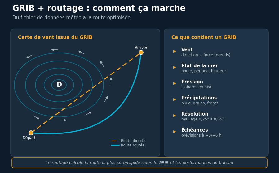
Two parameters deserve special attention. First, resolution: the spacing between grid points, expressed in degrees. A resolution of 0.25° is roughly 15 miles between points; a fine resolution of 0.05° drops to a few miles and better captures coastal effects such as thermal breezes. Second, the time step: a GRIB provides forecasts at regular intervals (every 3 or 6 hours, sometimes hourly on fine-scale models).
No need to download every layer: for a coastal trip, wind and pressure are enough and keep the file even smaller. Save swell and precipitation for offshore passages where sea state becomes decisive.
3. Where to download GRIBs
GRIB files draw on major numerical forecast models, each with its strengths:
- GFS (American model) — free, global coverage, medium resolution. The most widely used in leisure sailing.
- ECMWF (European model) — often rated the most accurate at medium range, but full access is paid.
- Arpège and Arome (Météo-France) — excellent on French coasts, with Arome a high-resolution model ideal for the shoreline.
- ICON (German model) — a solid free alternative, strong over Europe.
Several routes exist to fetch this data: navigation apps that download it directly onto the chart, e-mail services such as Saildocs for satellite links, and specialist web portals. The winning habit is to compare at least two models: if they agree, confidence rises; if they diverge, that is the sign of an uncertain situation calling for caution.
4. Weather routing: the principle
Having a GRIB is good. Knowing what to do with it is better. Weather routing calculates the optimal track between a departure point and a destination, factoring in the forecast weather along the whole route and the boat's capabilities.
The idea is easy to grasp: under sail, the straight line is almost never the fastest route. A sailboat cannot go straight into the wind and moves far faster at some angles than others. Routing evaluates thousands of combinations of headings and departure times, then proposes the one that minimises passage time — or maximises comfort and safety, depending on the chosen criterion.
In the diagram above, the direct route (dashed) crosses the heart of a low, where the wind is strong and the sea built up. The routed track (curved) skirts the area: it is longer in distance but faster and far safer because it uses favourable winds and avoids the bad weather.
Routing is not just for ocean crossings. Even on a 40-mile coastal leg, comparing two departure times can turn an uncomfortable beat into a pleasant close reach. Think of it before any demanding passage.
5. The role of the speed polar
To compute a route, the software needs to know how your boat performs: that is the speed polar. This diagram gives the boat's theoretical speed for every wind strength and every angle to the wind.
An accurate polar changes everything. Too optimistic, and routing promises unrealistic legs; too pessimistic, and it makes you leave too early or pick over-cautious routes. Many yards supply a stock polar, but nothing beats a polar tuned to your boat and your way of sailing, refined trip after trip.
| Point of sail | Wind angle | Behaviour |
|---|---|---|
| Close-hauled | 30–50° | Slow, uncomfortable; routing tries to avoid it |
| Close reach | 50–80° | Good speed / comfort compromise |
| Beam reach | 80–100° | Often the fastest point of sail |
| Broad reach | 100–150° | Fast and comfortable, the ideal angle |
| Running | 150–180° | Comfortable but not always the quickest |
6. Limits and pitfalls to know
GRIBs and routing are remarkable tools, but they are not reality itself. Several limits must stay in mind:
- Reliability falls with range. Beyond 72 hours, models diverge strongly. A 5-day route gives a trend, not a certainty.
- GRIBs often ignore local effects. Thermal breezes, terrain acceleration, headland effects: a global model does not see them. Only high-resolution models come close.
- Currents are not in a wind GRIB. In areas like the Raz de Sein or the Bay of Biscay, ignoring current completely distorts the calculation.
- Routing does not know the hazards. Shoals, restricted zones, traffic: it sometimes draws unworkable tracks. It is up to you to correct them.
A good routing is a starting point for thought, never an order to follow blindly. The sea remains in command.
7. Best practices
- Compare several models (GFS and ECMWF, for example) before any important decision.
- Favour short ranges when deciding to leave, and refresh your GRIBs at every new model run.
- Check the resolution: take a fine model near the coast, a global model offshore.
- Cross-check with official bulletins (Météo-France marine, gale warnings) that embed a forecaster's expertise.
- Keep perspective. An optimistic routing that grazes a gale is not worth a longer but serene track.
Conclusion
GRIB files have democratised a skill once reserved for racing navigators: watching the weather unfold on your chart and anticipating several days ahead. Paired with routing, they turn passage preparation into a methodical exercise rather than a gamble. But these tools are only worth as much as the skipper who knows their limits. Download, compare, route — then make your decision with the seamanship that, for its part, cannot be downloaded.
Read also
Marine weather, right on your chart
YachtMate shows wind, waves, swell and a 7-day forecast directly on your navigation chart. Free.
Discover YachtMate