Marine weather is the foundation of every safe passage. Yet between knots, the Beaufort scale, special weather bulletins and synoptic charts, making sense of it all is not always straightforward. This guide teaches you to read and interpret marine weather forecasts like a seasoned skipper, so you can make confident go or no-go decisions every time you head out on the water.
1. Where to find marine weather
Reliable weather information is available from multiple sources. The key is to cross-reference at least two of them before making any decision about going to sea.
- National weather services — Most countries have a dedicated marine forecast. In France, Météo France publishes coastal and offshore bulletins twice daily. The UK Met Office, NOAA (United States), and AEMET (Spain) offer similar services. These are the gold standard for accuracy and should always be your primary source.
- VHF radio — Weather bulletins are broadcast on VHF at regular intervals by coastguard stations. In many countries, a dedicated weather channel provides continuous updates. Always monitor VHF channel 16 while at sea.
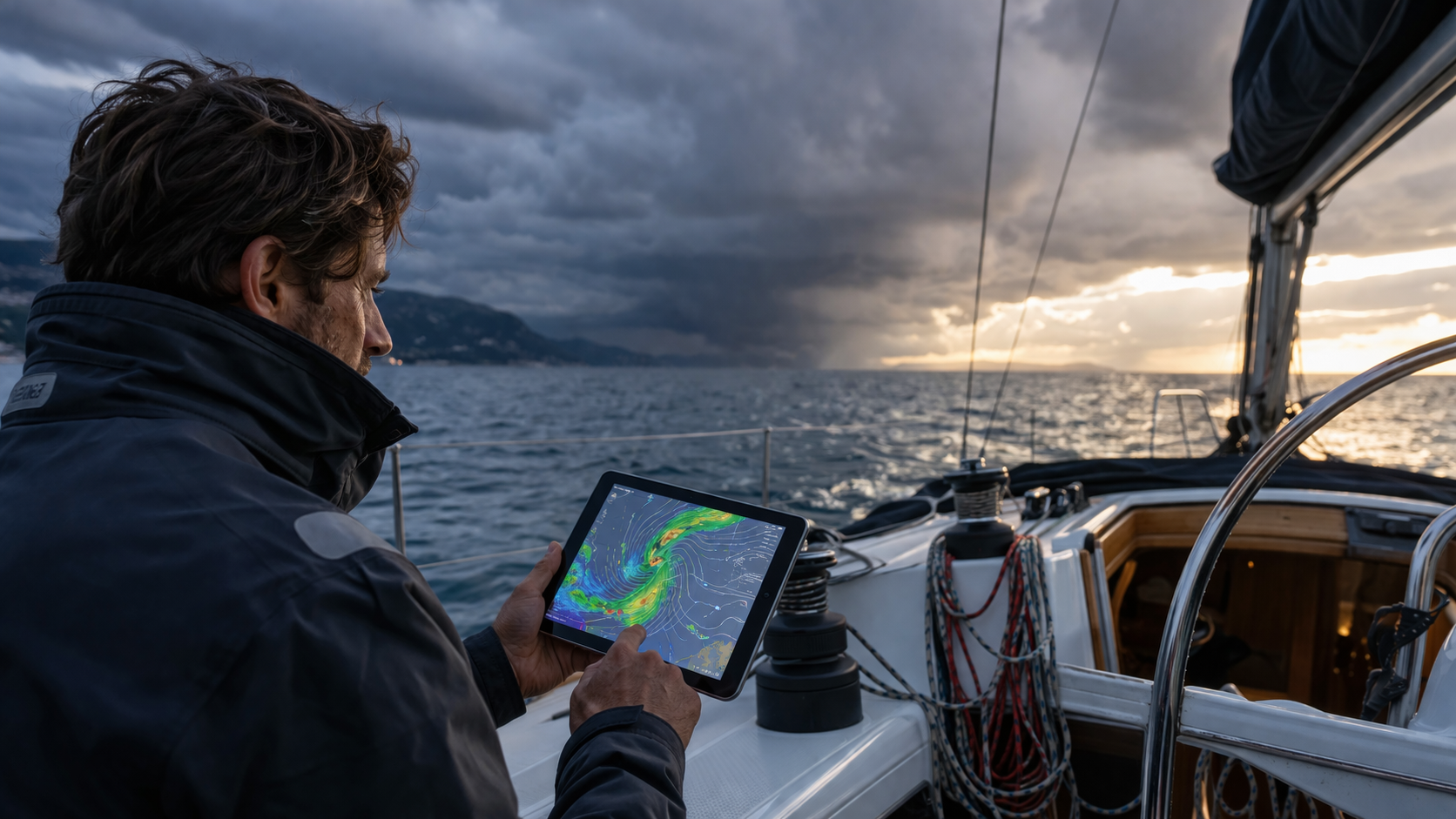
- Mobile apps — YachtMate integrates 7-day marine weather directly into the navigation chart, so you can check wind, waves and pressure without switching between apps. Other apps like Windy, PredictWind and Windguru are also popular among sailors.
- Harbour offices — Weather bulletins are typically posted at the entrance of every marina. Before casting off, walk to the harbour office and read the latest forecast — it takes two minutes and could save your life.
- GRIB files — For offshore passages, downloadable GRIB weather files give you gridded forecast data that you can overlay on your chart plotter. They are the go-to resource for passage planning beyond coastal waters.
In YachtMate, marine weather is accessible directly from the chart. You see current conditions and 7-day forecasts for wind, waves, swell and water temperature at a glance, without leaving the navigation screen.
2. Understanding wind
Wind is the single most important element in any marine weather forecast. It is expressed in knots (kn) and associated with a compass direction. Getting comfortable with these units and their practical implications is essential for every sailor.
The Beaufort scale
Devised in 1805 by Admiral Sir Francis Beaufort, this scale remains the universal reference for describing wind strength at sea. Every sailor should know it by heart.
| Force | Knots | Description | Sea state |
|---|---|---|---|
| 0 | 0 | Calm | Mirror-like sea |
| 1–2 | 1–6 | Light breeze | Small ripples, wavelets |
| 3 | 7–10 | Gentle breeze | Small waves, scattered whitecaps |
| 4 | 11–16 | Moderate breeze | Small waves, frequent whitecaps |
| 5 | 17–21 | Fresh breeze | Moderate waves, spray |
| 6 | 22–27 | Strong breeze | Large waves, white foam crests |
| 7 | 28–33 | Near gale | Rough sea, foam blown in streaks |
| 8+ | 34+ | Gale and above | Very rough to phenomenal sea |
For coastal recreational sailing, most crews are comfortable up to Force 4–5. Above Force 6, going out is inadvisable for inexperienced crews.
Wind direction
The direction given in a forecast is where the wind is coming from, not where it is blowing to. A north-west (NW) wind blows from the north-west towards the south-east. This is counter-intuitive for beginners but critical to get right, especially when choosing a sheltered anchorage or planning a passage.
Wind direction also determines which coastlines will be lee shores — dangerous shores to be near in strong winds because the wind pushes you towards them. Always identify the lee shore before heading out and plan your route to stay well clear.
Gusts versus sustained wind
Forecasts typically report sustained wind speed, but gusts can be 40–60% stronger. A forecast of 20 knots with gusts to 30 is a very different proposition from a steady 20 knots. Pay attention to gust factors, especially when deciding whether conditions are within your comfort zone.
3. Swell and waves
Marine forecasts distinguish between two types of sea disturbance, and understanding the difference is key to predicting how comfortable — or uncomfortable — your passage will be.
- Wind waves (sea) — These are waves created by the local wind. They are short, steep and chaotic, and they build quickly when the wind picks up.
- Swell — These are waves generated by distant weather systems far out at sea. They are long, regular and powerful, and they can arrive in calm weather with no local wind at all.
The two can combine to create a confused sea that is uncomfortable even in moderate wind. Pay close attention to the period (measured in seconds between wave crests): a 2-metre swell with a 12-second period is far more manageable than a 2-metre wind sea with a 5-second period. The longer the period, the gentler the motion.
When swell and wind waves come from different directions, the sea becomes particularly unpredictable. Boats roll, pitch and yaw simultaneously, making cooking, navigation and sleep difficult. If the forecast shows cross seas, consider delaying your departure.
4. Atmospheric pressure
Atmospheric pressure is expressed in hectopascals (hPa), also known as millibars (mb). The standard value at sea level is 1013 hPa. Your onboard barometer is one of the most valuable instruments you carry.
- Rising pressure → generally indicates improving weather (high pressure building)
- Falling pressure → suggests deterioration (a low-pressure system approaching)
- Rapid fall (more than 3 hPa in 3 hours) → imminent gale — stay in port!
The absolute value matters less than the trend. A barometer reading of 1005 hPa that is rising steadily is more encouraging than a reading of 1020 hPa that is falling fast. Get into the habit of logging the barometric pressure every few hours during a passage — the trend will tell you what is coming before you can see it.
In the tropics, pressure changes are subtler. A drop of even 3–4 hPa can signal a tropical storm. In higher latitudes, pressure swings of 10–20 hPa between systems are common. Context matters.
5. Special weather bulletins
National weather services issue special bulletins — known as BMS (Bulletin Météo Spécial) in France, or Gale Warnings and Storm Warnings in the UK and US — when dangerous conditions are expected. This typically means wind at Force 7 or above, or severely reduced visibility.
An active special weather bulletin means one thing: do not go to sea unless you are a highly experienced sailor with a vessel designed for heavy weather. These bulletins exist for a reason, and ignoring them is the leading cause of preventable maritime incidents.
Special bulletins are broadcast on VHF, displayed in harbour offices, and shown in marine weather apps. YachtMate displays active weather alerts directly in the app so you never miss one.
6. Reading a synoptic (isobaric) chart
Synoptic charts — also called surface analysis charts or isobaric charts — show lines of equal pressure (isobars) across a wide area. Learning to read them gives you a big-picture understanding of the weather that no point forecast can match.
- Closely spaced isobars = strong pressure gradient = strong wind
- Widely spaced isobars = weak gradient = light wind
- Centre marked "L" = low pressure (unsettled, windy weather)
- Centre marked "H" = high pressure (settled, fair weather)
- Cold front (blue triangles) = squalls, wind shift, showers, rapid clearing
- Warm front (red semi-circles) = cloud thickening, steady rain, gradual wind shift
- Occluded front (purple alternating) = complex mix of cold and warm front characteristics
In the northern hemisphere, wind blows roughly parallel to the isobars, with low pressure to your left. This is known as Buys Ballot's law and is extremely useful: if you stand with your back to the wind, the low pressure centre is to your left. This tells you instantly where the bad weather is.
7. The 5 golden rules
- Check the weather before every trip, even for a short afternoon sail. Conditions at sea can change dramatically in hours.
- Do not trust the blue sky you see in the morning. A beautiful sunrise means nothing if the forecast says Force 7 by afternoon.
- Know your limits — Force 5 is already demanding for a beginner crew. Be honest about your experience level and the capabilities of your boat.
- Have a plan B — identify a port of refuge along your route before you leave. If conditions deteriorate, you want to know where to go without having to make decisions under pressure.
- When in doubt, stay in port — the sea will still be there tomorrow. No sail is worth risking lives, and there is no shame in waiting for better weather. The best skippers are the ones who know when not to go.
Conclusion
Knowing how to read marine weather is the foundation of responsible seamanship. With practice, you will develop a weather instinct — the ability to look at the sky, feel the wind, check the barometer and sense what is coming. Until that instinct matures, rely on official forecasts, cross-reference your sources, and err on the side of caution.
The integrated weather in YachtMate gives you all the data at a glance, directly on your navigation chart. One app, one screen, everything you need to make the right call.
Read also
Marine weather built into your navigation
YachtMate displays wind, waves, swell and 7-day forecasts directly on the chart. Free.
Discover YachtMate