
A depression is the engine of bad weather in the Atlantic, the Channel and the Mediterranean alike. Learning to recognise its structure — where the fronts are, in what order they arrive, what they announce — turns an abstract weather chart into a story you can read and anticipate. This guide explains step by step how a weather system works, and how to turn that understanding into concrete decisions for your passages.
1. What is a depression?
A depression is an area where atmospheric pressure is lower than in the surrounding air. On charts it is marked with the letter L (for Low, or D on French documents) at the centre of concentric circles: the isobars. The lower the pressure at the core — 990, 980, sometimes below 960 hPa during winter storms — the deeper and more powerful the system.
Around this centre, the air spirals. In the Northern Hemisphere it turns anticlockwise, under the effect of the Coriolis force. This rotation explains why, at the helm, the wind does not blow straight from the centre towards you, but almost parallel to the isobars. It is also why the wind shifts predictably as the depression goes by: a major asset for the sailor who anticipates it.
An old but reliable rule, known as Buys-Ballot's law: in the Northern Hemisphere, turn your back to the wind — the depression lies to your left, slightly ahead.
2. How a weather system is born
Mid-latitude depressions are born on the polar front, the shifting boundary where cold air from the pole meets warm air from the tropics. When these two masses brush against each other, the slightest ripple amplifies: the lighter warm air begins to climb over the cold air, the centre deepens, and a swirling circulation organises. This is cyclogenesis.
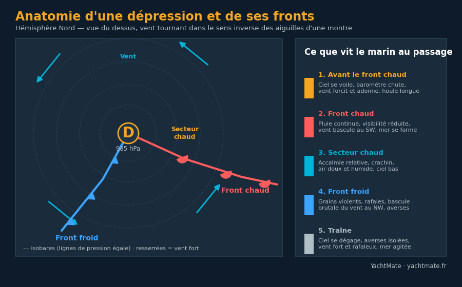
The system then takes on its characteristic comma shape, with two fronts running out from the centre: a warm front ahead and a cold front behind. Between them stretches the warm sector, a tongue of mild, humid air. The entire mechanism of the system plays out within this geometry.
A depression generally moves from west to east in our latitudes, at a speed of 20 to 50 knots. A system spotted 300 miles to the west may therefore reach you in 12 to 24 hours. Weather is never a surprise when you follow the trend.
3. The three fronts: warm, cold, occluded
A front is the contact zone between two air masses of different temperatures. This is where cloud, rain and wind shifts concentrate. There are three kinds.
The warm front
Shown in red with half-circles, it marks warm air advancing and sliding at a gentle slope over the cold air. The transition is gradual: the sky first veils with cirrus, then thickens, and the rain becomes continuous over a wide band. The wind strengthens steadily and visibility drops.
The cold front
Shown in blue with triangles, it marks cold air arriving and abruptly lifting the warm air ahead of it. Everything happens faster: violent squalls, showers, gusts, and a rapid wind shift. The cold front travels faster than the warm front — it eventually catches up with it.
The occluded front
When the cold front catches the warm front, the warm sector is lifted and pushed aloft: this is occlusion (shown in purple on charts). The depression then reaches maturity, then begins to fill. An occluded depression is often nearing the end of its life, but it can still generate strong wind and a rough sea.
4. The weather sequence as it passes
The great value of understanding this structure is that it translates into a predictable sequence. When a depression passes to the north of your position (the most common case in coastal sailing), you cross the different parts of the system one after another. Here is what you observe aboard:
| Phase | Sky & pressure | Wind | Sea |
|---|---|---|---|
| Ahead of the warm front | Banded cirrus, falling barometer | Strengthens, from SE then S | Long precursor swell |
| Warm front | Continuous rain, low ceiling | Veers to SW | Building, choppy |
| Warm sector | Lull, drizzle, mild air | Steady, sustained SW | Established wind sea |
| Cold front | Squalls, showers, brief clearings | Gusts, sharp shift to NW | Cross, confused |
| The clearance | Showery clearing sky | Strong and gusty, NW | Rough, slowly easing |
This reading gives you a decisive advantage: the wind shift as the cold front passes, from southwest to northwest, is often the trickiest. It can be abrupt, accompanied by a violent gust, and completely changes the orientation of your anchorage or the angle of your course. Anticipating it means avoiding the nasty surprise.
5. Reading the depression on a chart
On an isobaric chart (wind chart or synoptic chart), a few reflexes are enough to assess the situation:
- Tightly packed isobars = strong pressure gradient = strong wind. That is the first glance to take.
- Position of the fronts = where to expect rain and wind shifts. Spot the red, blue and purple symbols.
- Direction of movement = generally eastward; follow successive charts to estimate the time of arrival.
- Depth of the centre = the hPa value at the core indicates the power: below 980 hPa, expect heavy weather.
In YachtMate, marine weather is overlaid directly on your navigation chart: wind, gusts and pressure trend over 7 days, in your exact area. You can watch a system approach without cross-checking several sources.
6. Anticipate and decide
Understanding depressions is pointless if you don't draw decisions from it. Here are the reflexes of the prudent sailor:
- Watch the barometer trend, not just the value. A steady fall is the most reliable signal of a deterioration.
- Work out your window. If the cold front arrives in 6 hours and your destination is 4 hours away, go; otherwise, wait for the clearance.
- Pick the right side of the system. The sector south of the centre holds the strongest winds; passing to the north, calmer, can be worth a detour.
- Prepare the boat before the cold front. Reefs in early, crew ready, anchor set for the expected wind shift.
- When in doubt, stay in port. A depression fills in a day or two; patience is a sailor's skill.
Conclusion
A depression is no whim of the sky: it is a coherent mechanism, with a structure, an order of passage and warning signs. The sailor who can read a warm front, a warm sector and a wind shift turns anxiety into anticipation. Combine that understanding with official bulletins and clear weather on your chart, and every outing becomes a considered decision rather than a gamble.
Read also
Marine weather, right on your chart
YachtMate shows wind, gusts and the 7-day pressure trend in your sailing area. Free.
Discover YachtMate