
Moving from the world of the land to the world of the sea also means changing your units of measurement. At sea, we don't talk in kilometres, nor in kilometres per hour, and not quite in metres for depth either. The nautical mile, the knot, the cable, the fathom and degrees form a universal language shared by sailors all over the planet. Understanding these units and knowing how to convert them isn't a mere affectation: it's the foundation for reading a chart, calculating a route and estimating an arrival time. This guide walks through it all, simply.
The nautical mile: the primary distance at sea
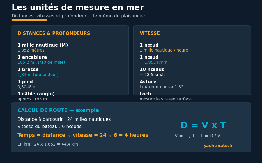
In navigation, the official unit of distance is the nautical mile (abbreviated M, NM or nm), which is exactly 1,852 metres. It's the unit you'll read on every chart, in sailing directions and on your electronic instruments. Don't confuse it with the Anglo-Saxon statute mile (1,609 m), which is shorter.
Why exactly 1,852 metres?
The nautical mile wasn't chosen at random: it corresponds to one minute of arc of latitude, that is 1/60th of a degree measured along a meridian. Since the Earth is 360 degrees around, and each degree equals 60 minutes, a full turn represents 21,600 nautical miles. This geometric elegance has a very practical consequence: on a nautical chart, the latitude scale (on the left and right edges) works directly as a ruler. One minute of latitude = one nautical mile. So you never need an external ruler to measure a distance.
The cable and the fathom
For short distances we use the cable, which is one tenth of a mile, or 185.2 metres. It's used, for instance, to indicate the distance to a hazard or a shoreline: "anchor two cables off the beach" means about 370 metres. The fathom, meanwhile, has historically been used to measure depth: it equals 1.83 metres (six feet), originally the span of a man's outstretched arms. You'll still find it on older Anglo-Saxon charts.
To measure a distance quickly on a paper chart, always take your reference from the latitude scale, never the longitude scale (which narrows towards the poles and distorts the measurement). A pair of dividers opened to one minute of latitude = one nautical mile.
The knot: measuring speed
Speed at sea is measured in knots (kn). One knot corresponds to one nautical mile covered in one hour. Saying a boat is "doing 6 knots" means it's moving 6 nautical miles per hour. It's the unit shown by your log (marine speedometer) and by your GPS.
Where does the word "knot" come from?
The term comes from an old measuring technique: the chip log. Sailors would stream a weighted line off the stern, marked at regular intervals by knots spaced about 15.4 metres apart. They counted how many knots ran out during a period timed by a 30-second sandglass. The more knots that passed, the faster the boat was going — hence the unit that has survived the centuries.
Converting knots and km/h
The conversion is easy to remember: 1 knot = 1.852 km/h. To go from knots to km/h, multiply by roughly 1.85. So 10 knots is about 18.5 km/h, and 20 knots about 37 km/h. The other way around, divide the km/h by 1.85. Keep this order of magnitude in mind: a cruising sailboat typically moves between 4 and 8 knots — the pace of a relaxed cyclist.
Speed through the water vs. speed over ground
Two speeds coexist on board, and confusing them can ruin a route calculation. Speed through the water is the boat's speed relative to the water: that's what the log measures. Speed over ground (SOG) is the speed relative to the seabed: that's what the GPS measures.
When the current pushes you, your speed over ground is greater than your speed through the water; when you're punching a current, it's the opposite. On a route through a 2-knot current, a boat making 6 knots through the water will actually move at 8 knots over the ground (fair current) or only 4 knots (foul current). To estimate an arrival time, it's always speed over ground that you must use.
YachtMate uses your smartphone's GPS to display your speed over ground in knots directly, with no log on board. It's the most reliable value for calculating your real passage time, current included.
Depth: metres, feet and fathoms
On modern French and European charts, depths (the soundings) are given in metres. But beware: many Anglo-Saxon charts, as well as many depth sounders, still show depths in feet (1 foot = 0.3048 m) or in fathoms (1 fathom = 1.83 m). Always check the unit stated in your chart's title block or your sounder's setting before reading a figure: confusing 6 feet (1.8 m) with 6 metres can have unpleasant consequences for the keel.
Likewise, your boat's draught (the submerged depth of the hull) and its air draught (the height above the water, up to the masthead) are figures to know in the same unit as your soundings, so you can judge a passage under a bridge or entry into a shallow area.
Calculating time, distance and speed
All route planning rests on a single relationship: Distance = Speed × Time. From this formula flow the other two: time equals distance divided by speed, and speed equals distance divided by time. Because the nautical mile and the knot are designed together (one knot = one mile per hour), the sums work out cleanly with no conversion.
A concrete example: you have to reach a port 24 nautical miles away and your boat holds an average of 6 knots. Passage time = 24 ÷ 6 = 4 hours. If you cast off at 9 a.m., you'll arrive around 1 p.m. (barring current and delays). For finer work, use the "rule of 60": distance covered in minutes = speed in knots. At 6 knots, you cover 6 miles in 60 minutes, so 1 mile every 10 minutes.
Always plan your timings around tides and currents: leaving with a fair current can save you an hour on a crossing and keep you from arriving at night or at low water in a port with a sill.
Angles, headings and bearings: degrees
Finally, directions at sea are measured in degrees, from 0 to 360, around the compass rose. North is 000° (or 360°), east 090°, south 180° and west 270°. Your heading is the direction the bow is pointing; a bearing is the direction of an object (a lighthouse, a buoy) relative to you. We distinguish true heading (relative to geographic north) from compass heading (relative to magnetic north), the gap between them being the variation, shown on every chart. Handling degrees with ease lets you plot a course, fix your position by cross bearings and follow a precise track.
These units — mile, knot, fathom, degree — can feel disorienting at first, but they form a coherent system tailored for navigation. Once they're second nature, reading a chart, estimating a passage time or reporting a position on the VHF all become effortless.
Navigate accurately with YachtMate
YachtMate shows your speed over ground in knots, your live GPS position, the distance to your next waypoint and your estimated time of arrival. No more mental conversions: the app plans your passages for you.
Discover YachtMate