Choosing the right marine navigation app is a bit like choosing a crew member: you need reliability, compatibility, and something that works under pressure. In 2026, the market has matured significantly, with established players and ambitious newcomers all vying for a spot on your cockpit tablet. Navionics, iSailor, OpenCPN, SailGrib, YachtMate — which one deserves a place on your device? This in-depth comparison examines the five leading apps to help you make the right choice for your style of sailing.
1. Why use a navigation app at sea?
A decade ago, navigating meant stacking paper charts, a hand-bearing compass and tide tables on the chart table. Today, a smartphone or tablet delivers computing power and GPS accuracy that would have seemed like science fiction to sailors of the previous generation.
Here is what a good navigation app brings to your cockpit:
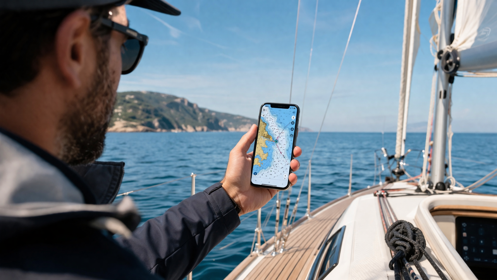
- Real-time positioning — Your boat is displayed on the chart with accuracy of a few metres. No more approximate bearings or estimated positions.
- Electronic charts — Marine charts integrate depth soundings, buoyage, restricted zones and port plans with impressive detail.
- Integrated weather — No more juggling three different sources: wind, waves and barometric pressure are accessible from the same screen.
- Route planning — Waypoints, distance calculation, ETA, proximity alerts — passage planning becomes intuitive and visual.
- Enhanced safety — Anchor alarms, AIS tracking, hazard zones: the app keeps watch when you cannot.
Of course, an app does not replace good seamanship or backup paper charts. But it has become an indispensable tool for sailing more safely and more confidently, whether you are day-sailing along the coast or crossing to the islands.
2. How to choose a navigation app
Not all navigation apps are created equal. Before comparing individual products, here are the five criteria that genuinely matter.
GPS accuracy and responsiveness
Positioning quality depends on both the GPS chip in your device and the software's processing. Some apps handle refresh rates and error filtering better than others. At sea, a few metres of accuracy can make the difference when threading a narrow channel.
Offline mode
Mobile signal disappears quickly once you leave the coast. An app that only works online becomes useless precisely when you need it most. Downloadable charts for offline use is a non-negotiable requirement for any serious navigation app.
Chart quality
Electronic navigational charts (ENCs) are not all identical. Some apps use official hydrographic service charts, others compile their own. Check the geographic coverage, update frequency and level of detail (soundings, buoyage, port plans).
Onboard features
Beyond the chart, the additional features often make the daily difference: integrated weather, logbook, anchor alarm, weather routing, port information, community feedback. Every sailor has different priorities.
Price and pricing model
From completely free to annual subscriptions exceeding 50 euros, pricing models vary widely. Watch for hidden costs: some apps are free to download but charge per chart region. Others offer an all-inclusive subscription. Value for money is what counts.
3. Navionics Boating
Navionics is arguably the best-known marine navigation app in the world. Acquired by Garmin in 2017, it benefits from exceptional cartography and a very active user community.
Strengths
- Benchmark cartography — Navionics charts are considered among the best available, with worldwide coverage and regular updates.
- SonarChart — High-definition bathymetric charts built from crowd-sourced sonar data. A unique asset for fishing and shallow-water navigation.
- Dock-to-dock routing — Automatic route calculation that accounts for draft and underwater hazards.
- Offline mode — Charts download easily for use without a network connection.
- Community — Thousands of user-contributed points of interest (anchorages, marinas, hazards).
Weaknesses
- Premium price — The annual subscription is around €50, making it one of the most expensive options.
- Busy interface — The wealth of features can make the interface overwhelming for beginners.
- No anchor alarm — Surprisingly absent for an app of this calibre.
- No logbook — You need a separate app to keep a ship's log.
Price: approximately €50/year (Navionics+ subscription).
Verdict: Navionics remains the gold standard for chart quality and global coverage. It is the right choice for sailors who need top-tier cartography and travel widely. The price is justified if you sail regularly in varied waters.
4. iSailor
iSailor focuses on official hydrographic service charts (SHOM, UKHO, etc.) and targets sailors who prioritise the authority and reliability of their chart data above all else.
Strengths
- Official charts — iSailor uses ENCs directly from national hydrographic offices, ensuring regulatory compliance and rigorous updating.
- Clean interface — The app is readable and intuitive, even for beginners.
- Pay-per-region — You only buy the charts you need, which can work out cheaper than Navionics if you sail in a limited area.
- Offline mode — All purchased charts are available without a connection.
Weaknesses
- Limited coverage — Coverage is primarily European. For a transatlantic, you would need to supplement.
- Basic features — No anchor alarm, no logbook, minimal weather integration.
- No community — No user-contributed feedback or shared waypoints.
- Paid updates — Charts must be renewed annually to stay current.
Price: approximately €35/year depending on regions purchased.
Verdict: iSailor is an excellent choice for European sailors who want official charts at a reasonable price. Its minimalism is both its strength and its limitation.
5. OpenCPN
OpenCPN is the open-source Swiss Army knife of marine navigation. Free, powerful, and backed by a passionate developer community, it is the go-to choice for technically minded long-distance sailors.
Strengths
- 100% free — Software, official charts (via hydrographic service ENCs), plugins: everything is available at no cost.
- Highly configurable — Dozens of plugins for AIS, GRIB weather, routing, radar overlay and more.
- NMEA compatible — Connects directly to onboard instruments (GPS, AIS, autopilot) via NMEA 0183/2000.
- Worldwide coverage — Access to ENCs from every hydrographic service on the planet.
Weaknesses
- Desktop-first — OpenCPN is designed for PC/Mac/Linux. The Android version exists but is less polished.
- Steep learning curve — Installing charts and plugins requires patience and technical comfort.
- Dated interface — The UI is functional but not modern. It feels like a tool built by engineers, for engineers.
- No native anchor alarm — Available via a third-party plugin, but not built in.
Price: free.
Verdict: OpenCPN is unbeatable for technically confident sailors who want a complete system at zero cost. It excels as a fixed navigation PC on board, less so for quick mobile use in the cockpit.
6. SailGrib
SailGrib stands out through its specialisation in weather routing. It is the app of choice for racing sailors and offshore navigators who want to optimise their route based on wind and current forecasts.
Strengths
- Advanced weather routing — SailGrib's routing engine is widely regarded as one of the best on mobile. It calculates the optimal route based on the boat's polar diagram, forecast wind and tidal currents.
- GRIB file support — Download and display weather GRIB files directly in the app for detailed forecast analysis.
- Multiple chart sources — Compatible with OpenSeaMap, ENCs and raster charts.
- One-time purchase — Around €25 with no recurring subscription.
Weaknesses
- Android only — SailGrib is not available on iOS, which excludes a large portion of sailors.
- Technical interface — The app targets experienced navigators. Beginners may find it confusing.
- No port information — SailGrib focuses on navigation and routing, not on shore-side services.
- No anchor alarm — Not part of the feature set.
Price: approximately €25 (one-time purchase).
Verdict: SailGrib is indispensable for anyone who does weather routing on Android. Its value for money is excellent for offshore sailors, but it lacks the versatility needed for everyday coastal cruising.
7. YachtMate
YachtMate is a newer entrant to the marine navigation market, designed in France by sailors for sailors. Its approach is different: rather than focusing solely on cartography, the app aims to be the complete companion for coastal cruising.
GPS and charting
YachtMate displays your position in real time on a marine chart and gives access to a database of 1,623 detailed ports covering France, Spain and Italy. Each port entry includes coordinates, available services, harbour office contact details and tariff information where available.
AnchorFix: the anchor alarm
This is YachtMate's signature feature. AnchorFix continuously monitors the boat's GPS position at anchor and alerts the skipper immediately if the boat drifts beyond a defined safety radius. The alarm runs in the background with the screen off, and includes automatic chain length calculation based on depth and weather conditions. It is the only app in this comparison to offer this feature natively.
AnchorFix automatically adjusts the safety radius based on chain length and depth. You can also set it manually if you prefer to keep full control.
7-day weather
Weather is integrated directly into the app with 7-day forecasts: wind (direction and strength), waves, temperature, atmospheric pressure. No need to switch to another app or website to plan your passage.
Digital logbook
YachtMate includes a digital logbook that records your passages. You can add notes and photos, and export everything as a PDF for your records or to satisfy regulatory requirements.
Community
YachtMate integrates a community space where sailors share experiences, report issues and exchange advice. A social network for mariners, built right into the navigation app.
Strengths
- Generous free tier — GPS, 1,623 ports, basic anchor alarm, weather, logbook: the free version covers the essentials.
- Unique AnchorFix — The only built-in anchor alarm on the market.
- All-in-one — Navigation, anchoring, weather, logbook and community in a single app.
- Competitive pricing — Premium at €29.90/year, roughly 40% less than Navionics.
- Built for coastal cruising — Optimised for the Mediterranean and Atlantic coasts.
Weaknesses
- Geographic coverage — Currently limited to France, Spain and Italy. Not suitable for a transatlantic.
- Offline charts in progress — Offline chart downloading is not yet available (coming soon).
- Young app — Less track record than Navionics or iSailor, though updates are frequent.
Price: free (comprehensive basic tier) / €29.90/year (Premium).
Verdict: YachtMate is the most complete app for coastal sailors in the Mediterranean and Atlantic. Its free tier is unmatched, and AnchorFix is a genuine innovation. One to watch closely as geographic coverage expands.
8. Comparison table
Here is a side-by-side summary of the key features of each app:
| Feature | Navionics | iSailor | OpenCPN | SailGrib | YachtMate |
|---|---|---|---|---|---|
| Price | ~€50/yr | ~€35/yr | Free | ~€25 | Free / €29.90/yr |
| Offline mode | Yes | Yes | Yes | Yes | Coming soon |
| Port database | Worldwide | Europe | Via charts | — | 1,623 (FR/ES/IT) |
| Anchor alarm | No | No | No | No | Yes (AnchorFix) |
| Weather | Basic | Basic | Via GRIB plugin | GRIB files | 7-day integrated |
| Logbook | No | No | No | No | Yes (PDF export) |
| Weather routing | No | No | Via plugin | Yes (advanced) | No |
| Community | Yes | No | Forum | No | Yes (in-app) |
| Platforms | iOS / Android | iOS / Android | PC / Mac / Android | Android only | iOS / Android |
| Best for | Global cruisers | European coastal | Tech-savvy sailors | Offshore routing | Coastal Med/Atlantic |
9. Which app for your profile?
The best app depends entirely on how and where you sail. Here are our recommendations by profile.
The weekend coastal sailor
You sail most weekends along your local coast, visit nearby ports, and anchor for lunch or overnight. YachtMate is the ideal choice: free, all-in-one, with AnchorFix for peace of mind at anchor and a logbook to track your adventures.
The globe-trotting cruiser
You sail long distances, visit different countries each season, and need reliable charts everywhere you go. Navionics is your best bet for worldwide cartographic coverage. Consider supplementing with YachtMate for anchoring and logbook features in the Med.
The tech-savvy navigator
You enjoy configuring systems, connecting instruments and having full control over your setup. OpenCPN on a dedicated navigation PC gives you maximum flexibility at zero cost. Add SailGrib on Android for weather routing on passage.
The racing sailor
You need optimal routing and GRIB weather analysis. SailGrib is purpose-built for this and represents outstanding value. Pair it with a charting app for the navigation essentials.
The new boat owner
You have just bought your first boat and want one app that covers everything without complexity. Start with YachtMate's free tier: it covers navigation, anchoring, weather, safety equipment tracking and logbook. Upgrade to Premium as your needs grow.
Conclusion
There is no single "best" navigation app — only the best app for your particular needs. The good news is that in 2026, the quality across the board is remarkably high. You can navigate safely and confidently with any of the apps reviewed here.
Our advice: start with the free options (YachtMate and OpenCPN), identify what you actually use and what you feel is missing, and then invest in a paid solution only if the free tier leaves a genuine gap. For the majority of coastal sailors, YachtMate's free version covers everything you need — and then some.
Read also
Try YachtMate free
GPS navigation, AnchorFix anchor alarm, 7-day weather, digital logbook, 1,623 ports — all free. See for yourself.
Discover YachtMate