Radar technology stands as one of the most revolutionary innovations in modern maritime navigation. Since its introduction during World War II, radar has become indispensable for safe navigation, particularly in conditions of poor visibility. Whether navigating through thick fog, heavy rain, or traversing a congested strait, radar provides you with a clear view of the world around you – where your eyes cannot see. This comprehensive guide will enable you to master this essential technology and optimize its use for safer navigation in all conditions.
Understanding Radar Fundamentals
Radar operates on a simple yet elegant principle: it emits electromagnetic waves and analyzes the echoes that return after striking objects. These echoes are processed in real time to create a visual image of your surrounding environment. Typical range varies between 12 and 48 nautical miles depending on the model and conditions. The fundamental advantage of radar is that it works regardless of darkness, fog, rain, or snow – anything that defeats traditional optical navigation methods.
Radar Technology Types: Pulse vs. Broadband
Traditional pulse radar systems emit short, powerful waves, then listen for echoes. This technology is reliable and well-established, performing well for detecting metal structures and vessels. However, CHIRP (Compressed High Intensity Radar Pulse) technology and broadband radars represent a major evolution. These systems emit a signal across a range of frequencies, improving resolution and reducing interference. CHIRP systems offer significantly better target definition, allowing you to distinguish between a buoy and a fishing vessel at the same distance – a critical capability for navigation in busy waters. Doppler radars, while less common on pleasure craft, offer additional benefits by detecting the relative movement of targets, helping identify approaching or departing vessels. For most recreational navigators, a CHIRP system offers the best compromise between cost and performance, delivering clear imagery with reduced false targets.
X-Band vs. S-Band Selection Criteria
Choosing between X-band (10 GHz) and S-band (3 GHz) depends on your navigation needs and sailing patterns. X-band offers superior resolution and a sharper image, essential for navigating congested coastal waters. It detects small objects and structures well, making it ideal for harbor approaches and confined waters. However, X-band signals are attenuated by rain and heavy precipitation. S-band, operating at lower frequency, penetrates heavy rain and thick fog better, making it more suitable for offshore passages and extreme weather conditions. Many experienced navigators choose X-band for coastal waters and S-band for ocean voyages.
Installation and Technical Considerations
Installing a radar requires careful planning. The radar antenna, typically mounted on the mast or cockpit arch, must have an unobstructed line of sight. Optimal positioning significantly increases detection range and image quality. Poor antenna placement is one of the most common reasons radar systems underperform.
Antenna Mounting and Positioning Best Practices
On sailing yachts, the antenna is often mounted on a stainless steel bracket fixed to the cockpit arch or mast top. This elevated position offers superior coverage across 360 degrees. Ensure the antenna is at least 2 meters away from all sensitive electronic equipment to avoid interference with navigation systems or communications. The antenna's rotation must be free and unobstructed – sails or rigging must not block the signal. For sailboats, many navigators mount the antenna at the very top of the mast for maximum elevation and unobstructed coverage in all directions.
Power Consumption and Electrical Requirements
Modern radars consume between 50 and 150 watts in active mode, representing a significant load on your electrical system. Ensure your alternator and batteries can support this demand, particularly during extended night navigation. Calculate total electrical load including autopilot, navigation systems, refrigeration, and radar. Renewable energy systems (solar panels, wind turbines) are excellent supplements for navigators who use radar regularly. A 200-watt solar panel coupled with 400 watts of wind generation provides adequate power for full-time radar operation even during extended cruising.
Reading and Interpreting the Radar Display
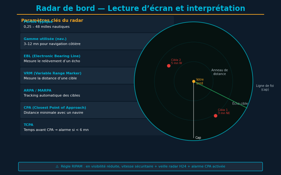
The radar screen presents you with a circular or rectangular view of your environment. Learning to correctly interpret this image is key to safety. The display shows your vessel at the center, with echoes displayed as bright dots or colored zones depending on your system configuration.
Understanding Echoes and Radar Traces
On a radar screen, your vessel sits at the center of the display. Echoes appear as bright dots or white/green zones depending on your system. Metal vessels create strong, clear echoes that appear as distinct bright spots. Small wooden fishing boats or wrecks may produce weaker echoes and appear as faint traces. Coastlines appear as dense, continuous return areas with irregular patterns. What matters most is recognizing patterns: a small isolated blip is likely another vessel, while an irregular broken line is the coast. Oil rigs appear as distinct bright spots. Rain appears as fuzzy, diffuse returns. Learning to distinguish these patterns takes practice but is essential for effective radar use.
Measuring Tools: EBL and VRM Explained
EBL (Electronic Bearing Line) and VRM (Variable Range Marker) are crucial measuring tools built into your radar system. EBL allows you to measure a target's bearing by drawing an electronic line from your position to the target. VRM measures distance by drawing concentric circles at specific ranges. Using these tools together, you can determine with precision the distance and bearing of a potentially dangerous vessel. For collision avoidance, plot two successive bearing and distance measurements several minutes apart to determine target course and speed. If bearing remains constant while distance decreases, collision risk exists. Practice regularly with these features – in calm conditions first, then progressively in more complex environments with multiple targets.
Clutter Control and Advanced Filtering
One of radar's greatest challenges is managing unwanted echoes. Rain, snow, fog, and waves all create radar noise that can mask real targets. Understanding and properly adjusting your radar's filtering capabilities is essential for effective use. The rain clutter filter eliminates echoes generated by precipitation, while the sea clutter filter reduces noise from wave returns. These filters must be adjusted based on current conditions. Over-aggressive filtering can eliminate real targets; insufficiently aggressive filtering leaves excessive noise obscuring important information. Most modern radars offer automatic settings that adjust these parameters continuously, but experienced navigators often prefer manual control for greater precision in specific conditions.
Guard Zones and Advanced Alarm Functions
Guard zones allow you to define sectors where an alarm triggers if a target appears. During night navigation, you can set a forward zone to be alerted of any approaching vessel. Behind-the-beam zones prevent wake or other false targets from triggering unnecessary alarms. This function, combined with an integrated AIS system, creates a comprehensive anti-collision surveillance system. Set alarms for closing targets within guard zones, with configurable range and bearing parameters based on vessel traffic in your area.
Radar Integration with AIS and Chartplotters
Modern radar systems often connect with other navigation equipment through NMEA networks. Integration with AIS (Automatic Identification System) shows you not only radar echoes but also vessels transmitting their position, speed, and course via AIS. A chartplotter displaying both radar and AIS data provides complete situational awareness of maritime traffic around you. This integration is invaluable for understanding the intentions of nearby vessels – you can see their names, destinations, and projected courses.
MARPA and Advanced ARPA Systems
MARPA (Mini-Automatic Radar Plotting Aid) is available on recreational navigation radars. Once a target is selected, MARPA automatically tracks its movement and calculates its course and speed. ARPA (Automatic Radar Plotting Aid), more sophisticated systems on commercial vessels, offer automatic collision-risk calculations based on predicted closest point of approach. For most sailing yachts, MARPA is sufficient for safe navigation, providing the essential information needed for collision avoidance without unnecessary complexity.
Using Radar for Collision Avoidance and Navigation
Radar is your primary tool for collision avoidance, particularly at night or in poor visibility. A vessel sleeping without radar in a congested strait puts crew and boat at serious risk. Many marine accidents occur because navigators failed to use available radar effectively. At night or in thick fog, radar becomes your eyes. Analyze the radar screen regularly – not continuously (which causes fatigue), but every 5–10 minutes systematically. Observe trends: a vessel whose bearing remains constant while distance decreases represents a potential collision risk. Alter your course or speed early enough to create a clearly perceptible separation. Avoid making multiple small course adjustments; instead, make one obvious, substantial course change that other radar operators will immediately recognize.
MOB Detection and Anchor Watch Functions
Many modern radars offer MOB (Man Overboard) functionality. Pressing the MOB button marks the exact spot and can guide you back to the area. Some systems automatically activate the autopilot to hold position and mark the coordinates in your chartplotter. For anchoring, you can set a guard zone around your anchor position: if radar detects you're drifting beyond set limits, an alarm activates, waking you if you're resting. This function has saved countless vessels during the night from dragging anchors.
Maintenance, Costs, and Model Selection
Radar maintenance is relatively straightforward. Regularly check that the antenna rotates without obstruction and verify the electrical connections are clean and corrosion-free. Keep the screen clean and dry. Unlike older generations, modern radars are robust and require little maintenance beyond occasional cleaning and inspection. Radar systems for sailing yachts vary considerably in price and capability. Basic systems (€8,000–€15,000) offer reliable detection with range up to 24 nautical miles, suitable for coastal cruising. Mid-range models (€15,000–€30,000) add features like MARPA, AIS integration, superior resolution, and larger displays. High-end systems (€30,000+) are generally reserved for large vessels or professional navigators. For a typical cruising sailboat of 35–50 feet, a mid-range system offers excellent value, providing all features necessary for safe navigation without unnecessary complexity.
Use Cases and Best Practices
Radar excels in several scenarios where it becomes literally life-saving. Coastal navigation in fog, passage through congested straits like the English Channel or Mediterranean passages, nocturnal surveillance of high-risk zones, and anchoring in reduced visibility are situations where a good radar can mean the difference between safe passage and serious incident. Establish a radar watch schedule during potentially hazardous passages, with designated crew responsible for regular radar monitoring. Practice regularly with your radar even in good weather. Compare radar echoes with what you actually see: this reinforces your system understanding and builds confidence. Familiarize yourself with all buttons and menus before venturing into difficult conditions. A mastered radar is an invaluable safety asset for any navigator.
Conclusion
Radar is far more than an electronic gadget – it's essential safety equipment for modern maritime navigation. Whether navigating along Breton coasts, the Mediterranean, or the open ocean, understanding and mastering this technology will enhance your navigational competence and increase your safety. Investments in a good radar system and training in its use are among the wisest an owner can make. The radar has proven its value countless times in preventing collisions and enabling safe navigation when visibility fails. Make it a core part of your navigation strategy.
Navigate smarter
YachtMate uses radar and AIS to help you navigate with confidence.
Discover YachtMate →