In the age of GPS and navigation apps, celestial navigation may seem like a relic of the past. Yet knowing how to fix your position with a sextant, an accurate watch and a few tables remains a valuable — even vital — skill the moment you leave the coast behind. An electrical failure, a lightning strike that fries the electronics, or a simple software bug, and an offshore yacht suddenly has no position. The sextant never breaks down. This guide introduces the fundamental principles of navigating by the stars.
What is celestial navigation?
Celestial navigation means determining your position on the globe by measuring the altitude of a celestial body — the Sun, the Moon, a planet or a star — above the horizon, at a very precise moment. By cross-referencing that measurement with the ephemeris (the known positions of the bodies) and the exact time, you obtain a line of position: a line on the chart along which the boat must lie. Two or three intersecting lines give you a fix.
The technique rests on an old but unbeatable principle: at any given instant, every celestial body sits directly above one unique point on Earth. The closer you are to that point, the higher the body appears in the sky. The sextant measures that angular altitude precisely, and that is where all the magic begins.
Start with the Sun. It is the easiest body to observe: visible, large and thoroughly documented. The famous "meridian passage" (measuring the Sun's altitude as it crosses the meridian at solar noon) gives you latitude directly, with no complex calculation. It is the ideal exercise for beginners.
The sextant: anatomy of the instrument
The sextant is a precision optical instrument whose name comes from its graduated arc, which spans one sixth of a circle (60°). It measures the angle between two directions — typically between a celestial body and the horizon line. Its main components are:
- The limb: the arc graduated in degrees, from 0 to around 120°.
- The micrometer drum: allows a fine reading, down to the arc-minute (1/60 of a degree).
- The index mirror: fixed to the moving arm, it reflects the image of the body.
- The horizon mirror: half-transparent, it lets you see the horizon while superimposing the body's image.
- The shade glasses: essential for observing the Sun without burning your retina.
- The telescope: to magnify and sharpen the sight.
The principle of the sight
Taking a "sight" means measuring the altitude of a body. In practice, the observer looks at the horizon through the horizon mirror, then moves the arm until the image of the body (reflected by the index mirror) just "touches" the horizon line. The angle read on the limb is the sextant altitude (Hs). The diagram below sums up the geometry and the steps of the process.
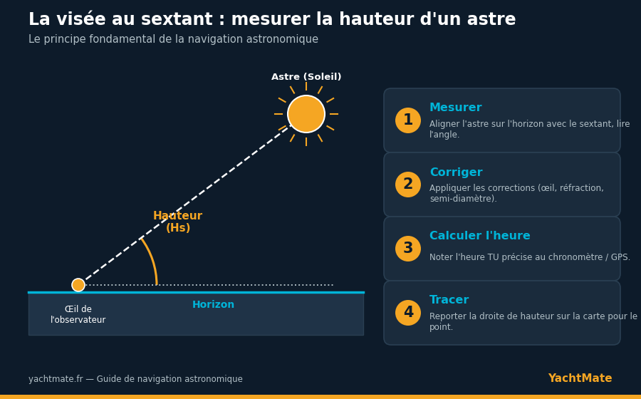
For the Sun, the classic technique is to bring the lower edge (the lower limb) of the body down to the horizon, then gently swing it to find the lowest point of its arc — the moment when the body truly grazes the horizon. At that precise instant, you note the time on the chronometer.
The essential corrections
The raw altitude read on the sextant is never directly usable. Several corrections must be applied to obtain the true altitude (Ho):
Index error
No sextant is perfect. The index error is measured by sighting the horizon at the theoretical zero: the observed offset must be added to or subtracted from every measurement. It is the first check to make before any series of sights.
Dip of the horizon
From a boat's deck, the eye sits above sea level, so the horizon appears slightly "lowered." This dip depends on the height of the eye above the water and is corrected using tables.
Atmospheric refraction
Starlight is bent as it passes through the atmosphere, making bodies appear higher than they really are. Refraction is greatest near the horizon, which is why we avoid bodies that are too low (below 15° of altitude).
Semi-diameter
For the Sun and Moon, you sight an edge of the body rather than its center. You must therefore add (or subtract) the semi-diameter, roughly 16 arc-minutes for the Sun.
The exact time matters as much as the angle. A 4-second error in timing shifts your fix by about 1 nautical mile in longitude. Use a reliable chronometer, or carefully note the UTC time shown by your GPS or phone at the moment of the sight — that is the one genuinely useful "modern" shortcut.
From calculation to plotting on the chart
Once the true altitude is obtained, you compare it with the "computed" altitude for an estimated position, using the nautical almanac and reduction tables (such as HO 249 or HO 229). The difference, called the intercept, tells you by how many miles the line of position must be shifted relative to the estimated position, toward the body or away from it.
You then draw a line perpendicular to the direction of the body (the azimuth). The boat lies somewhere on this line. By repeating the process with a second body — or, for the Sun, by combining a morning sight with a noon sight — the lines cross and give the position. Today, dedicated calculators and apps greatly simplify the calculation while keeping the manual sextant measurement.
Why learn it in 2026?
Electronic navigation is reliable, but not infallible. Battery failure, electrical damage, GPS signal jamming or spoofing, lightning: scenarios of lost position genuinely exist offshore. Celestial navigation offers a fully self-sufficient redundancy, depending on no power source and no network. It is also a deeply rewarding discipline that reconnects the sailor to the sky, to time and to celestial mechanics. Many offshore sailing schools still teach it, and rightly so.
"GPS tells you where you are. The sextant teaches you why." — a well-known saying among offshore navigators.
You don't need to be a mathematician to start: with an entry-level sextant, a nautical almanac and a little practice at anchor, you can master the Sun meridian in a few sessions. It is the first step toward a level of navigational self-reliance that few recreational sailors still possess today.
Sail with peace of mind with YachtMate
Nautical charts, weather, anchorages and navigation tools: prepare every passage and stay on course, even far from the coast.
Discover the app