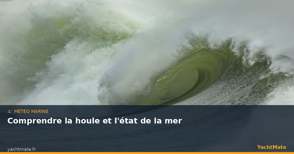
We readily talk about wind strength before setting off, but it is often the sea state that really decides the comfort and safety of a passage. A 15-knot breeze can give an almost flat surface inside a sheltered cove, or a steep, confused sea off a headland exposed to the swell. Learning to tell swell from wind sea, and to read the figures in a forecast (height, period, direction), radically changes how you anticipate a day out.
In this guide, YachtMate explains how waves are born, what the terms you see in weather files really mean, and how to turn those numbers into concrete decisions: go, wait, or pick a different route.
How waves are born
It all starts with the wind. As it blows over the surface, it transfers its energy to the water, first creating small ripples, then larger and larger waves. Three factors determine the size of the waves generated: the wind strength, its duration (how long it has been blowing) and the fetch, that is, the distance of open water over which it acts without obstruction.
This is why identical winds do not produce the same sea everywhere. Close to a lee shore, the fetch is short: the sea stays manageable even in a fresh breeze. Offshore, or when the wind blows across hundreds of miles of open water, the waves have the time and the space to grow. Understanding the local fetch is one of the keys to anticipating the real sea state in your area.
Before you leave, note the forecast wind direction and ask yourself where the fetch comes from. An offshore wind often gives you a protected surface along the coast, whereas the same wind established out at sea can build a hard sea. A chart and the wind direction are enough to avoid plenty of surprises.
Swell and wind sea: two different things
The two are often confused, but they behave nothing alike. The wind sea is made up of waves generated locally by the wind blowing right now. It is typically short, confused, crested with foam, with closely spaced waves that form and collapse quickly. It is a "young" sea, directly tied to the wind you feel.
The swell, on the other hand, is an "old" sea: these are waves that were generated elsewhere, sometimes very far away, by a distant storm or a wind that has since died. As they travel, these waves organise, lengthen and become regular. Swell is longer, smoother and more predictable — but it can cross areas where there is no wind at all. A perfectly sunny, windless sea can still be disturbed by a large swell coming from a depression 500 miles away.
In practice, the real sea is often the combination of both: an underlying swell with the wind sea of the moment superimposed on it. It is this superposition that sometimes creates uncomfortable cross seas, when swell and wind sea come from different directions.
The vocabulary of waves: height, period, length
To describe a sea, we use a few precise quantities. Knowing them lets you read a forecast or a GRIB file without getting it wrong.
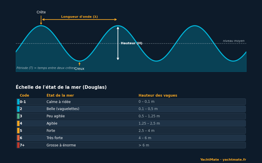
Height
A wave's height is measured between trough and crest. But be careful: forecasts do not give the biggest wave, nor the average, but the significant wave height — the average of the highest third of the waves. It is a reliable statistical reference, but one that hides an important reality: individual waves can be considerably higher. In practice, expect to see waves of around 1.5 to 2 times the announced significant height regularly, and occasionally more.
Period
The period is the time between the passage of two successive crests at a fixed point, expressed in seconds. It is probably the most underrated figure among recreational sailors, even though it describes the character of the sea. A short period (5 to 7 seconds) signals tight, choppy waves, typical of an uncomfortable wind sea. A long period (10 to 15 seconds and more) reveals a powerful swell with widely spaced undulations: at equal height it is gentler under the boat, but it carries a great deal of energy and can become dangerous when breaking over shallows.
Wavelength
This is the horizontal distance between two crests. It is linked to the period: the longer the period, the more spaced out the waves. A long-wavelength sea cradles the boat; a short sea shakes it. The ratio between height and length (the wave's "steepness") also determines its risk of breaking: it is the short, high waves that break most easily.
Never look at wave height without looking at the period. 2 metres at a 12-second period is a long, comfortable swell; 2 metres at 5 seconds is a short, tiring sea. On the same forecast, two identical height figures can describe very different conditions.
Reading the sea state: the Douglas scale
To sum up the state of the sea in a word, sailors use the Douglas scale, which runs from 0 (calm sea, like a mirror) to 9 (phenomenal sea). Each degree corresponds to a range of wave height, as summarised in the table above. "Rough sea" (degree 4) thus corresponds to waves of 1.25 to 2.5 metres, already demanding for a small craft, while a "slight sea" (degree 3) remains accessible to most well-handled boats.
This scale is valuable because it turns figures into a feel. But it does not tell the whole story: the same height can be comfortable or punishing depending on the period, the direction relative to your route, and the possible presence of current. A degree-4 sea against an opposing current can become much harder than the number suggests.
The traps: current, shallows and cross seas
Several phenomena can turn a reasonable sea into a dangerous one. The first is current against the swell. When a tidal current opposes the waves, they steepen, shorten and break: well-known passages, certain headlands or narrows become navigable or not depending on the direction of the current. This is the classic "wind against tide" situation, to be avoided whenever possible.
The second is swell arriving over shallows. In shallow water, the swell "feels the bottom": it slows down, grows and eventually breaks. An innocuous offshore swell can thus become a dangerous bar at a harbour entrance, on a sill or a beach. This is why the entrances to some harbours are discouraged in big tides and heavy swell from a given direction.
The third is the cross sea: when swell and wind sea come from different directions, their crests meet and create, in places, pyramid-shaped waves that are higher and more unstable. The sea looks confused and the boat is worked from all sides. It is a tiring situation for the crew and one that demands extra attention at the helm.
"It is not the height of the wave that hurts the prudent sailor, but the one he did not anticipate. The sea is read before it is endured."
Turning the wave forecast into decisions
All this theory is only worth anything if it guides your choices. Before each outing, get into the habit of cross-checking four elements: the significant height, the period, the direction of the swell and that of the wind, and the expected evolution over the coming hours. Then ask yourself how that sea will present itself relative to your route: head-on, it slows you and shakes you; on the beam, it heels and rolls the boat; from astern, it pushes but can make you broach.
Finally, think about the sheltering effect of the coast and the state of the tide. The same day can offer a manageable sea in the morning with an offshore wind, then deteriorate in the afternoon when the sea breeze sets in and builds a wind sea against the residual swell. Anticipating these windows means sailing in the best part of the day rather than the worst.
Set your own comfort and safety thresholds based on your boat and crew: for example "no more than 1.5 m significant height or a period under 6 seconds for a family outing". Having clear limits before you check the weather avoids decisions made under the pressure of wanting to go.
Checklist before you leave
To quickly assess the forecast sea state, run through this routine:
- Note the significant height and remember that some waves will be 1.5 to 2 times higher.
- Check the period: short = choppy sea, long = powerful but more regular swell.
- Record the directions of swell and wind, and compare them to your route.
- Look for the traps: opposing current, shallows, exposed harbour entrances, cross seas.
- Identify the sheltering effect of the coast and the best time window.
- Set your limits in advance and stick to them, even if it means postponing the outing.
Swell and sea state are not data reserved for offshore sailors: they are the parameters that make the difference between a fine day and an ordeal, even for a coastal outing. With a little practice you will read a sea forecast as naturally as the weather in the sky — and you will choose your sailing windows one step ahead.
🌊 Read the sea before you leave with YachtMate
YachtMate brings marine weather, wind and wave files, charts and AIS together in a single app. Visualise the height, period and direction of the swell to choose your windows with confidence.
Download YachtMate for free