
For the sailor dreaming of trade winds, turquoise lagoons and long ocean passages, the tropical cyclone remains the most feared weather threat. These vast systems concentrate a phenomenal amount of energy: winds exceeding 250 km/h, monstrous seas and storm surges capable of devastating an entire coastline. The good news is that cyclones are now remarkably well forecast and, above all, entirely avoidable for anyone who understands the seasons, the risk areas and the escape tactics. This guide covers everything a navigator needs to know to never cross paths with a hurricane.
What is a tropical cyclone?
A tropical cyclone is a huge, swirling depression that forms over warm oceans where the sea surface temperature exceeds roughly 26.5 °C over at least 50 metres of depth. Intense evaporation releases a colossal amount of latent heat that feeds the system in a self-sustaining spiral. Unlike depressions in temperate latitudes, a tropical cyclone has no fronts: it is an almost symmetrical heat engine, powered by the warmth of the ocean.
Anatomy of a cyclone
Three zones characterise the structure of a mature cyclone. The eye, at the centre, is a surprisingly calm area 20 to 60 km across where the wind eases and the sky may even clear — a deceptive calm, because the worst is yet to come. Around the eye, the eyewall concentrates the most violent winds and the heaviest rainfall. Finally, the spiral bands radiate out over hundreds of kilometres, bringing successive squalls, a building swell and a rapidly falling barometer.
Hurricane, typhoon or cyclone: the same beast
The phenomenon is identical everywhere; only the name changes with the ocean basin. It is called a hurricane in the North Atlantic and North-East Pacific, a typhoon in the North-West Pacific, and simply a cyclone in the Indian Ocean and South Pacific. A crucial detail for the sailor: in the Northern Hemisphere the rotation is counter-clockwise, and in the Southern Hemisphere it is clockwise. This difference determines the entire avoidance strategy.
Cyclone season: where and when?
The golden rule of offshore cruising boils down to one sentence: never be in a cyclone zone during its risk season. The world's great sailing routes (the famous "trade wind routes") are in fact built entirely around this principle. Here are the main windows to remember:
- North Atlantic and Caribbean — Official season from 1 June to 30 November, with a marked peak from mid-August to mid-October.
- North-East Pacific — From mid-May to late November.
- North-West Pacific (typhoons) — Risk all year round, but especially from June to November.
- South Indian Ocean and South Pacific — Reversed season, from November to April (austral summer).
This is why east-to-west Atlantic crossings are traditionally made in November and December (after the season), and why boats wintering in the Antilles often head further south (Grenada, Trinidad) or up to the United States before summer.
Many yacht insurance policies impose "named-storm zones and dates": your boat must be south of a certain latitude (often 12° 40' N in the Antilles) or out of the zone during the season, or cover is void. Always check this clause before planning your itinerary.
The Saffir-Simpson scale
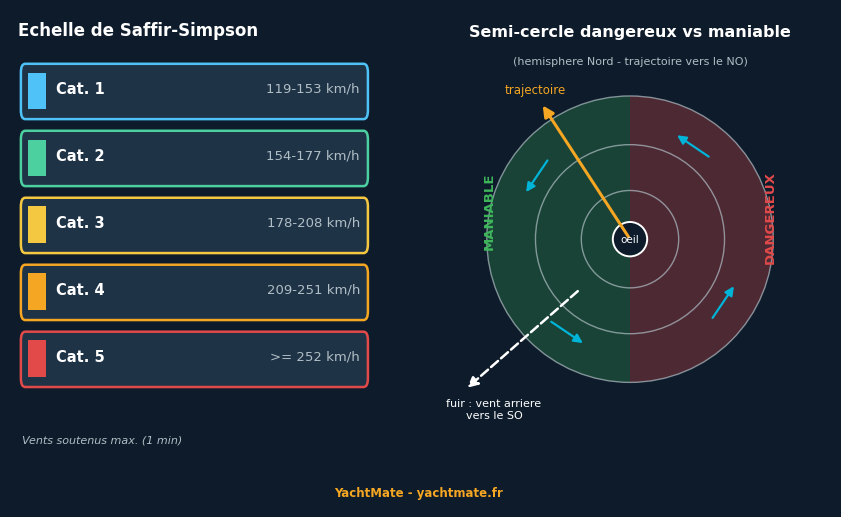
To quantify the power of a hurricane, we use the Saffir-Simpson scale, graded from 1 to 5 according to sustained wind speed. A system becomes a Category 1 hurricane from 119 km/h; it reaches Category 5 above 252 km/h — winds capable of dismasting a boat, capsizing it and generating a swell several metres high hundreds of miles away. Below the 119 km/h threshold we speak of a tropical storm (63 to 118 km/h), already more than enough to put a sailboat in serious trouble.
Remember that a category is not fixed: a cyclone can intensify rapidly (sometimes by two categories in 24 hours) over very warm water. This is why forecasts always include a "cone of uncertainty" that widens over time.
The dangerous semicircle
If, despite every precaution, a cyclone threatens, the fundamental concept to master is that of the two semicircles. In the Northern Hemisphere the wind turns counter-clockwise while the system moves forward: on the right-hand side of the track (relative to the direction of travel), the rotational wind speed adds to the cyclone's forward speed. This right side is the dangerous semicircle: the strongest winds, and above all a wind that tends to push the boat towards the path of the centre.
The left side is the navigable semicircle: the winds are less violent there and tend to carry the boat away from the centre. In the Southern Hemisphere everything is reversed — it is the left side that becomes dangerous.
A memory aid for the Northern Hemisphere: if the wind veers (shifts clockwise as you track it), you are probably in the dangerous semicircle, to the right of the track. If the wind backs (shifts counter-clockwise), you are in the navigable semicircle. Always run off downwind or on a broad reach towards the navigable sector, away from the forecast path of the centre.
Anticipate: weather sources and warning signs
Today no sailor should be caught out by a cyclone: specialist centres (the National Hurricane Center for the Atlantic, WMO regional centres elsewhere) publish bulletins and forecast cones several days ahead. On an offshore passage, you receive this information via GRIB files, NAVTEX and SafetyNET bulletins, or a satellite link.
Nature itself sends signals you must learn to read: a long, building swell from an unusual direction (often the first clue, hundreds of miles from the system), a sharp, continuous fall in the barometer, thin converging cirrus, then a thickening sky and a rising sea. In the tropics, a barometric drop of more than 3 to 5 hPa below the local average should immediately raise the alarm.
What to do if a cyclone threatens?
The strategy depends on your situation. The best choice is almost always not to be there: if the forecast allows time, make for a safe harbour clear of the track, or put maximum lateral distance between you and the cone. A few principles:
- Ashore — Reach a well-known "hurricane hole" (a sheltered mangrove, a cyclone-rated marina), double up the mooring lines, remove all sails and as much windage as possible (bimini, sprayhood, solar panels), and physically leave the boat: no vessel is worth a life.
- At sea, at a distance — Manoeuvre to stay in the navigable semicircle and run off downwind, moving away from the forecast path of the centre.
- At sea, caught in the system — Reduce sail to the bare minimum, prepare a drogue and heavy-weather rig, harness and jacklines compulsory, and close every hatch. Survival comes before course.
"You do not fight a cyclone, you avoid it. The best anti-cyclone tactic is played out weeks in advance, on the calendar and on the chart, long before the first gust."
In summary
Tropical cyclones are the most violent phenomena a sailor can encounter, but they are also the most predictable. Safety rests first on planning: respecting the cyclone seasons of each basin, knowing your insurance clauses and building your route to stay out of the zone at the wrong time. As a last resort, understanding the dangerous semicircle and knowing how to read a falling barometer or a long swell lets you make the right decisions in time. At sea as at anchor, anticipation is your best defence.
Keep an eye on the weather with YachtMate
Wind, swell and pressure forecasts, GRIB files, marine charts and AIS: YachtMate brings together everything you need to sail with peace of mind. The navigation app built for boaters, on iOS and Android.
Discover YachtMate →