
The blue sky clouded over in an hour. On the horizon a dark mass stretches out, low and threatening, sometimes capped by a white anvil. Beneath it the sea looks ragged, almost smoking. You have just spotted a squall — and if it lines up with others to form a squall line, you had better know what is coming. Sudden gusts, a wind shift, blinding rain and sometimes thunder: a squall packs into a few minutes everything that can catch a boater off guard. This guide explains how it forms, how to spot it in time and, above all, how to manoeuvre through it safely.
1. What is a squall?
A squall is a local, short-lived disturbance tied to a convective cloud — usually a large towering cumulus or a cumulonimbus. It brings a sudden, marked rise in the wind, a change in its direction, and often precipitation: a shower, hail, sometimes thunderstorm activity. Unlike the established wind of a depression, which builds gradually over hours, a squall strikes within minutes then moves off just as fast.
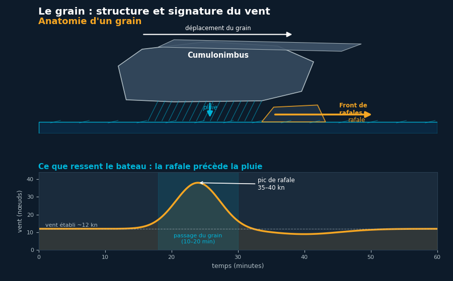
Intensity varies enormously. A moderate squall adds 10 to 15 knots to the ambient wind; a severe cumulonimbus squall can send the wind leaping from 15 to more than 40 knots, with gusts that knock down a boat carrying the wrong sail area. It is this suddenness, more than the peak value, that makes the phenomenon dangerous: there is no time to reduce sail if nothing has been anticipated.
2. How a squall line forms
An isolated squall comes from a single convective cell: warm, moist air rises, condenses aloft, and the shower that falls drags a mass of cold air downward. This cold air spreads out along the surface as it reaches the water: that is the gust front, the blast of wind felt just before the rain.
When several cells organise into a chain — along a cold front, a convergence line or a vigorous sea breeze — they form a squall line that can stretch for dozens of miles. These lines often move faster than the individual cells and sweep across a whole area. In the Mediterranean in summer they readily accompany late-day thunderstorms; in the Atlantic they precede or follow the passage of a front. Learning to read the clouds and checking precipitation radar images is the best way to anticipate them.
A squall gives little warning: between the moment you spot it on the horizon and the first gust, less than twenty minutes often pass. That window is your preparation time.
3. Spotting an approaching squall
Several converging signs should put you on alert:
- A dark, compact cloud with a low base, often blue-black, sometimes capped by the anvil typical of a cumulonimbus.
- A rain shaft visible under the cloud, blurring the horizon and giving a hazy, greyish look.
- A horizontal roll cloud at the leading edge (the arcus), the mark of a well-organised gust front.
- A sea turning white in the distance: the surface bristles with whitecaps under the gust before the wind even reaches you.
- A shift or a drop in the established wind, sometimes a deceptive calm just before the squall breaks.
At night, onboard radar and lightning become your best allies: a dense blob on the radar screen that grows and closes in betrays an active cell. A jumping barometer and a rapid fall in air temperature often confirm the arrival of the sinking cold air.
4. What to do as it approaches: anticipate the gust
The golden rule fits in two words: reduce early. You do not ride out a squall under full mainsail; you meet it already shortened down. As soon as the squall is identified and coming your way, work through it methodically:
- Warn the crew and have them put on lifejackets and harnesses; clip on if the deck is slippery.
- Reduce sail: take one or two reefs, roll in some genoa. Better under-canvassed for ten minutes than over-pressed at the wrong moment.
- Close hatches, companionway and portholes so you do not take on water.
- Fix your course: note your heading, the dangers around you and the position of other boats before the rain cuts visibility to a few dozen metres.
- Under power if needed, ease off but keep enough way on to manoeuvre.
Anticipate the shift: in the northern hemisphere the wind in a squall often veers (turns clockwise) as the gust arrives. Set your course so the first gust hits you at a manageable angle — never beam-on under too much sail.
5. While it passes over
When the gust hits, the boat heels hard: that is normal if you are properly canvassed. Under sail, bear away slightly to ease the pressure and let the mainsheet run in an overpowering gust; never cleat anything hard. Under power, keep the bow into the roughest sea and adjust your speed. Visibility can drop to nothing under the shower: slow down, switch on your navigation lights, watch for traffic and keep an eye on radar and AIS.
The worst rarely lasts more than ten to fifteen minutes. Stay calm, hold your safe heading and avoid any abrupt manoeuvre. Hail, if it comes, is unpleasant but brief; the priority is to stay covered and not be caught out by the cross sea a squall sometimes raises.
6. After the squall
Once the cell has passed, the wind often drops as fast as it rose, leaving a rough sea and a sky clearing from behind. Do not shake out the reefs too soon: first check that no other squall follows in the line, which is common. Bring the sail back progressively once the train of cells has gone through.
Log the time, peak strength and direction of the squall. On a squall line these notes help you estimate the spacing of the following cells and decide when it is safe to shake out sail.
7. Mistakes to avoid
- Waiting to reduce. "It might pass to one side" is the bet that costs a torn sail or a broach. Reduce at the first doubt.
- Keeping the sheet cleated. In a gust, a mainsail sheeted flat and jammed is unforgiving; always keep the ability to ease quickly.
- Ignoring visibility. Charging into the rain shaft with no lights or radar watch, near shipping lanes, risks a collision.
- Shaking out too soon. On a line, the calm between two squalls is deceptive: a second, even a third, often follows behind.
- Neglecting weather prep. Reading the marine forecast and the Beaufort scale before setting out lets you anticipate days of convective risk.
Frequently asked questions
Is a squall always a thunderstorm?
No. Many squalls are limited to a hard shower with a gust of wind, without lightning. But as soon as a well-developed cumulonimbus is involved, electrical activity becomes possible: this is a thunder squall, to be treated with extra caution.
How long does a squall last?
The most violent passage generally lasts five to twenty minutes for an isolated cell. A squall line can affect your area for one to two hours, cell after cell.
How can I anticipate squalls before setting out?
Watch for marine forecasts mentioning a risk of showers or thunderstorms, check precipitation radar images and convection models, and beware of hot, unstable afternoons — especially in the Mediterranean in summer and as a cold front approaches in the Atlantic.
Stay ahead of the weather with YachtMate
Marine forecasts, wind, charts and real-time navigation: keep an eye on the sky and prepare every trip with confidence.
Discover the app