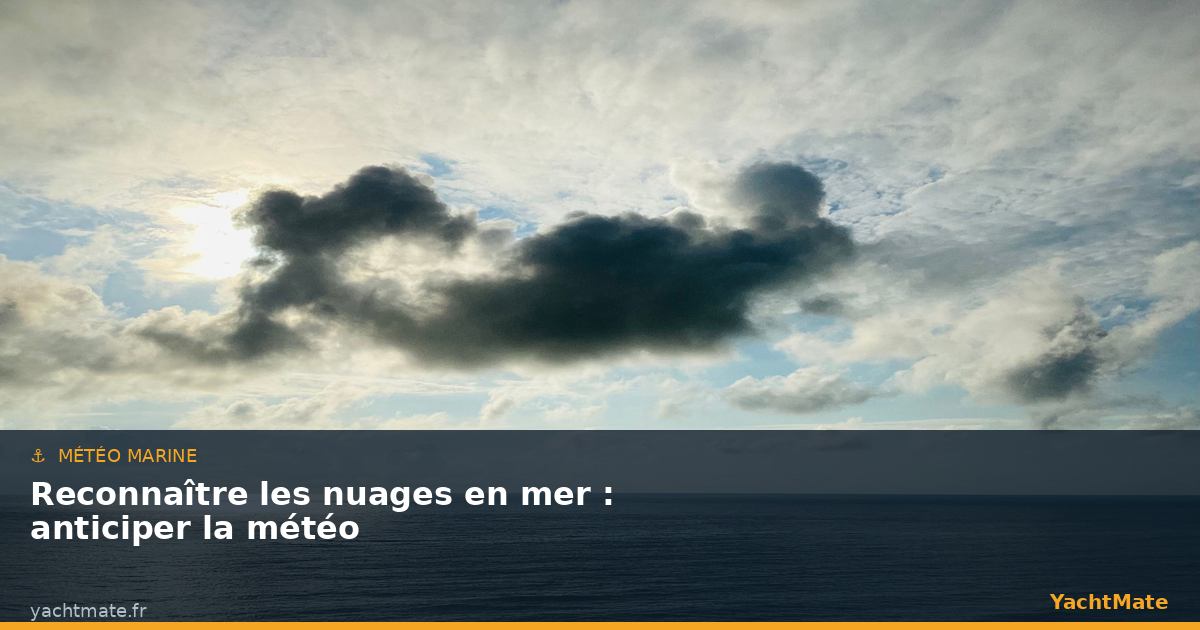
Long before the barometer and GRIB files, sailors read the weather in the sky. Even today, knowing how to recognise clouds remains one of the most valuable reflexes for any boater: it is a free, local and immediate forecast that perfectly complements official bulletins. A veil spreading across the horizon, "mackerel scales" multiplying, a dark tower growing through the afternoon — these are all signals the sky sends you hours before the wind picks up.
In this guide, YachtMate explains how to classify clouds by altitude band, what each type announces, and above all how to read their evolution to anticipate a change in weather. Because it is not an isolated cloud that matters, but the sequence it traces across the sky.
Why the sky is still a navigation instrument
Weather forecasts cover wide areas and are issued several hours in advance. At sea, your local situation can change faster than the bulletin, particularly near coasts, in gulfs or in unstable conditions. Direct observation of the sky bridges that gap: it tells you what is happening right now, above your head, and the trend for the hours to come.
Three elements are read together: the shape of the clouds (filaments, layers, towers), their altitude (high, middle, low) and their evolution over time. A sky that gradually hazes over, clouds that lower and thicken, a falling pressure: the convergence of these signs almost always announces an approaching disturbance.
Get into the habit of noting the state of the sky at fixed times, for example at every watch change. By comparing your observations with the barometer trend, you spot a deterioration well before it becomes visible on the water. YachtMate displays the barometric curve alongside the forecast.
The three cloud bands
Clouds are classified by the altitude of their base into three main families. Each band corresponds to characteristic types and a different meteorological meaning. Memorising this table means giving yourself the means to translate the sky into a forecast.
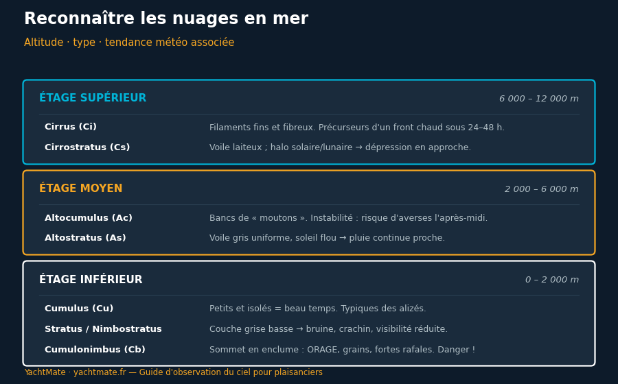
High clouds are made of ice crystals, low clouds of water droplets. The thicker and lower a cloud is, the more likely it is to produce precipitation. And the faster the sky changes, the closer the change of weather.
The high band: the messenger clouds
Located between 6,000 and 12,000 metres, these are often the first messengers of a change. Taken alone they bring no rain, but their appearance and gradual thickening deserve your full attention.
Cirrus (Ci)
Thin, white and fibrous, shaped like filaments or "mares' tails", cirrus glide high in the sky. A few scattered cirrus in stable fair weather are nothing to worry about. But if they thicken and invade the sky from the west, they often announce the approach of a warm front within 24 to 48 hours. The deterioration is still distant, but it is brewing.
Cirrostratus (Cs)
A milky, transparent veil that whitens the whole sky. Its most recognisable sign is the halo ringing the sun or moon, caused by light refracting through ice crystals. A well-marked halo is a classic warning: a depression and its frontal system are drawing closer. If the veil lowers and turns into altostratus, rain is no longer far off.
The middle band: the deterioration confirms itself
Between 2,000 and 6,000 metres, these clouds generally mark a more advanced stage in the evolution of the weather.
Altocumulus (Ac)
They form layers of small, regular flakes — the famous "mackerel sky" — sometimes aligned in rolls. In the morning, tightly packed altocumulus signal an unstable atmosphere: they can announce showers or thunderstorms during the day, especially if the heat builds. The old saying "mackerel sky, never long wet, never long dry" sums up their changeable nature.
Altostratus (As)
A grey or bluish, uniform veil through which the sun appears as if behind frosted glass, with no halo and no shadows on the ground. Altostratus is a cloud of imminent rain: it shortly precedes the continuous precipitation of a warm front. When the sky darkens and lowers, prepare the boat and the crew.
When the sun moves from a sharp halo (cirrostratus) to a blurred disc with no shadow (altostratus), the cloud system is thickening and lowering: rain and stronger wind are approaching. This is the right moment to shorten sail or choose a sheltered anchorage.
The low band: the present weather
Below 2,000 metres, these clouds reflect the current weather. They are also the ones that produce most precipitation and, for one of them, the most dangerous phenomena.
Cumulus (Cu)
Small white clouds with a flat base and a budding top, well separated from one another: these are the clouds of fair weather, typical of sunny days and trade-wind regimes. Keep an eye, however, on their vertical development: cumulus that grow quickly and stretch upwards can turn into large shower clouds.
Stratus and Nimbostratus
Stratus is a low, uniform grey layer that can reach the surface as mist or fog and severely reduce visibility. Nimbostratus, thicker and darker, is the cloud of continuous rain: steady precipitation, a low ceiling and an often built-up sea. These are uncomfortable but rarely violent conditions.
Cumulonimbus (Cb)
This is the cloud you absolutely must know. A huge dark tower whose top spreads into an anvil, the cumulonimbus is the storm cloud: intense rain, lightning, hail, and above all squalls with brutal gusts and unpredictable wind shifts. A line of cumulonimbus on the horizon demands caution: shorten sail in anticipation, brief the crew and, if possible, steer clear of its path.
"The sky speaks to those who know how to listen. A cumulonimbus is not up for debate: you prepare for it before it arrives, never during."
Reading the sequence: how a front reveals itself
The most common mistake is to judge a cloud in isolation. The real information is in the succession. The typical arrival of a warm front reads like this: first cirrus to the west, then a veil of cirrostratus with a halo, next altostratus greying the sky and lowering the ceiling, and finally nimbostratus and rain. This progression can unfold over one to two days and leaves you time to decide.
The passage of a cold front is more abrupt: it often shows as a line of large cumulus and cumulonimbus, violent but brief squalls, followed by a clearing sky and a gusty, veering wind. Always pair your reading of the sky with the barometric trend: a rapid drop in pressure confirms a deterioration, a rise announces an improvement.
The direction in which high clouds move tells you about the trend. In the northern hemisphere, the "crossed-winds rule" holds that if the high clouds move to the right of the surface wind, the weather tends to deteriorate; to the left, it tends to improve. An old but useful check to confirm the trend.
Mediterranean and Atlantic: different skies
In the Atlantic and the Channel, the weather is governed by the succession of depressions coming from the west: frontal sequences are clear there and reading the cloud bands works particularly well. Advection fog is also common in spring and summer.
In the Mediterranean, instability is often more local and more sudden. The build-up of cumulonimbus at the end of a summer's day, sometimes linked to violent thunderstorms and downbursts, can surprise you with its speed. Watching the vertical growth of cumulus in the afternoon is essential there, especially near coastal relief.
Sky-watching checklist
To turn your observations into decisions, keep a simple routine in mind, to be applied several times a day:
- Look to the west — that is where most disturbances come from in our latitudes.
- Identify the dominant band: high, middle or low clouds.
- Note the evolution since your last observation: is the sky hazing over, lowering, thickening?
- Look for a halo around the sun or moon — an early sign of an approaching depression.
- Watch vertical developments in the afternoon: a budding cumulus can become a cumulonimbus.
- Cross-check with the barometer and the forecast before any decision on route or anchorage.
Recognising clouds does not replace a weather bulletin, but completes it and brings it to life. With a little practice, your eyes will become a full-fledged onboard instrument — the one that warns you first, while the horizon is still clear.
🌤️ Keep an eye on the sky with YachtMate
YachtMate brings marine weather, wind files, charts and AIS together in a single app. Cross-check your sky observations with the forecast to decide, with confidence, when to set off and when to head back.
Download YachtMate for free