At sea, weather information can mean the difference between a safe passage and a dangerous situation. NAVTEX (NAVigational TEleX) is the international system for the automatic broadcast of weather bulletins and maritime safety notices. Simple, robust and free, it is fitted on the vast majority of sailboats and motorboats venturing offshore. Here is everything you need to know to use it effectively.
What is NAVTEX?
NAVTEX is a digital radio communications system that continuously broadcasts maritime safety messages on dedicated frequencies. Developed in the 1980s and integrated into the Global Maritime Distress and Safety System (GMDSS), it is now mandatory on SOLAS vessels and strongly recommended for offshore leisure sailing.
The principle is simple: a coastal station transmits digital telex messages at regular intervals. Your receiver, left permanently switched on, picks up these transmissions and prints or displays them automatically — with no action required on your part. Even while you sleep, NAVTEX keeps watch.
Why NAVTEX is essential offshore
Unlike weather apps that require an internet connection, NAVTEX works anywhere at sea, with no subscription and no mobile network. It is a passive system: it receives, you do not transmit. Its reliability makes it the ideal complement to other weather sources (VHF weather radio, Windy, GRIB files).
Combine NAVTEX with the YachtMate app to cross-reference received bulletins with GRIB forecasts downloaded in port. This double check helps you better anticipate weather changes during coastal or offshore passages.
NAVTEX Frequencies
NAVTEX uses three main frequencies:
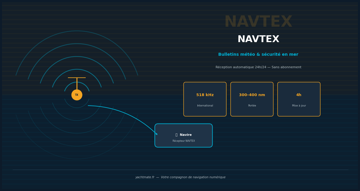
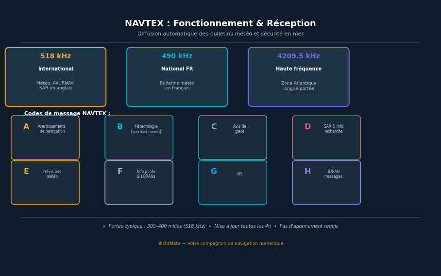
518 kHz — The international frequency
This is the worldwide reference frequency. All messages are broadcast in English: weather, urgent navigation warnings (AVURNAV), SAR information, beacon faults. Its typical range is 300 to 400 nautical miles. In the Mediterranean and Atlantic, transmitters cover virtually all areas frequented by leisure sailors.
490 kHz — The national frequency
This frequency allows countries to broadcast bulletins in their national language. In France, Météo-France broadcasts weather bulletins in French on 490 kHz via French Navy coastal stations. Range is comparable to 518 kHz. For French-speaking sailors navigating French waters, this is a valuable and more readable source.
4209.5 kHz — The high frequency band
Reserved for long ocean passages and remote areas, this frequency offers significantly greater range (several thousand miles) through ionospheric propagation. It is mainly used for offshore sailing beyond the coverage areas of MF transmitters.
Decoding NAVTEX Message Codes
Every NAVTEX message begins with a 4-character header: ZCZC [X][Y][ZZ] where X is the transmitting station code, Y is the message type, and ZZ is the message number. Understanding Y lets you filter messages relevant to your passage.
- A — Navigational warnings: obstacles, mines, wrecks, defective lights
- B — Meteorological warnings: strong winds, gale warnings
- C — Ice notices
- D — SAR information and search and rescue notices
- E — Meteorological forecasts: regular bulletins (24h, 48h)
- F — Pilot service and LORAN navigation aid messages
- G — AIS messages
- H — LORAN messages
- L — Additional navigational warnings (rebroadcast)
On your receiver, you can usually choose to display only certain categories. For coastal leisure sailing, categories A, B, D and E are the most important. Avoid activating everything to prevent your display from being overwhelmed.
Your NAVTEX receiver stores the numbers of already-received messages and will not display them again. If you are crossing several station zones, make sure your receiver is set to accept messages from all transmitting stations along your route.
Choosing and Installing a NAVTEX Receiver
Types of receivers
There are two main categories of NAVTEX receivers:
- Dedicated standalone receivers: self-contained units with a built-in display (e.g. Standard Horizon NX-300, Furuno NX-500). Robust, easy to read, with integrated printer on some models. Ideal for boats with a dedicated chart table.
- Chartplotter-integrated receivers: many modern GPS chartplotters (Garmin, Simrad, Raymarine) include a NAVTEX module. Messages appear directly on the chart screen — an elegant solution for a clean cockpit.
The antenna: the key to good reception
Reception quality depends above all on the antenna. NAVTEX operates on medium waves (MF), which requires different antennas from VHF. Options include:
- Dedicated whip antenna: optimal solution, recommended length 2 to 4 metres
- Loop (frame) antenna: compact, good directivity, ideal for sailboats
- Coupling on SSB antenna: possible if you have an SSB transceiver on board
Avoid sharing the VHF antenna — the frequencies are incompatible. Mount the antenna as high and clear as possible to maximise range.
Connection and power supply
The NAVTEX receiver must be powered continuously (12V DC). Current consumption is very low (generally less than 0.5 A), which poses no problem even at anchor. Connect it directly to a dedicated fuse in the electrical panel, with an accessible switch.
YachtMate lets you plan your passages using available weather forecasts. During your crossing, complement this data with NAVTEX bulletins received on board for a complete, updated weather picture every 4 hours.
NAVTEX Areas and Transmitting Stations
The worldwide NAVTEX coverage is divided into geographic zones, each covered by coastal stations identified by a letter. In French and adjacent waters, the main stations are:
- Station W (Niton/UK): Eastern Channel, North Sea approaches
- Station T (Tarifa/Spain): Strait of Gibraltar, western Mediterranean
- Station S (La Garde/France): north-western Mediterranean, Gulf of Lion
- Station A (Corsen/France): north-east Atlantic, western Channel, Bay of Biscay
Reading a NAVTEX Bulletin
A typical NAVTEX weather bulletin looks like this:
ZCZC SA12
161620 UTC APR 2026
MEDITERRANEAN SEA - NORTHWEST PART
GALE WARNING
GULF OF LION : WIND SW 7 VEERING W 8 LOCAL GUSTS 9.
SEA : VERY ROUGH.
NNNN
Decoding is straightforward: SA12 = station S (La Garde), type A (navigational warning), message number 12. Then the date-time in UTC, the geographic zone, and the content. Wind scales use the Beaufort scale and standard WMO abbreviations. Wind directions indicate the wind's origin (SW = wind from the south-west).
NAVTEX vs Other Weather Sources
NAVTEX is not the only weather source on board. Here is how it fits into your weather toolkit:
- NAVTEX: reliable, automatic, independent. Ideal for safety warnings and 24–48h forecasts. No charts, no graphics.
- VHF weather radio: coastal bulletins broadcast by coast guard stations. Complementary for coastal sailing.
- GRIB files: high-resolution numerical models, downloadable in port. Excellent for planning.
- Weather apps (Windy, PredictWind, etc.): visual, intuitive, but require internet. Not available offshore without a satellite connection.
- Iridium / SSB: for ocean passages, the only way to get fresh weather data anywhere on the globe.
The golden rule in marine weather: never rely on a single source. NAVTEX provides the safety baseline — an automatic alert even when you are not actively monitoring — that other systems cannot guarantee on their own.
Plan Your Passages with YachtMate
YachtMate centralises all your navigation information: checklists, logbook, maintenance log and weather forecast access. Available on iOS and Android, it is the ideal companion for sailing with complete peace of mind — at sea or at anchor.
Download YachtMate for FreeConclusion
NAVTEX is a fundamental safety tool for any sailor venturing offshore. Affordable, easy to use, and completely independent of internet or mobile networks, it guarantees automatic reception of the most important weather bulletins and navigational warnings. Combined with good pre-departure forecast reading and an app like YachtMate underway, it perfectly completes your on-board weather safety system.
Do not wait for the next storm to take an interest in it: install your NAVTEX before your next offshore passage.