
The Mediterranean presents highly variable sailing conditions shaped by season, geography, and latitude. While often romanticized as an idyllic sailing destination, this inland sea demands sophisticated understanding of seasonal patterns, regional wind systems, and navigational hazards. Successful Mediterranean sailing requires mastery of synoptic chart reading, GRIB file interpretation, and intimate knowledge of local wind behaviors. This comprehensive guide equips you with essential knowledge for planning safe and rewarding cruises throughout this legendary sea, whether navigating the Mistral-swept Golfe du Lion or the predictable Meltemi of the Aegean. Understanding these seasonal variations transforms casual sailors into confident maritime navigators.
Seasonal Calendar and Optimal Cruising Periods
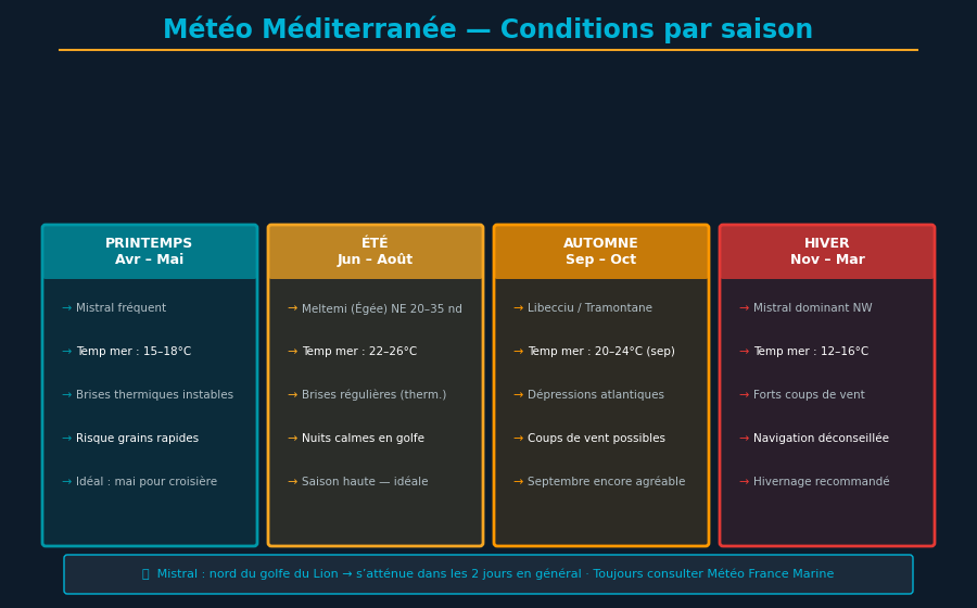
Mediterranean sailing divides into three distinct seasonal phases with pronounced meteorological characteristics. High season runs May through September, with May and September offering the most stable and predictable conditions throughout the year. July and August remain popular but feature increased thermal wind development and occasional intensification of depressionary systems. April and October comprise transition periods often offering excellent compromise between meteorological stability and reduced tourist congestion, appealing particularly to discerning sailors seeking quality without crowds.
High Season: May through September with Monthly Details
May marks the authentic beginning of Mediterranean cruising season. High-pressure systems strengthen progressively from North African latitudes, delivering northwesterly winds that remain relatively predictable. Air temperatures (18-22°C) and water temperatures (16-18°C) feel cool but tolerable for properly equipped navigators. Frontal storms become rare, coastal morning mists dissipate quickly, and atmospheric pressure remains elevated above 1015 hectopascals throughout the month. This period attracts discerning sailors who value predictability over myths of perpetual calm. Residual Atlantic spring storm swells attenuate progressively through May, rendering seas gradually calmer.
June through August constitute the genuine apex for Mediterranean coastal cruising. Thermal wind patterns dominate meteorological signatures, particularly the Marin (southeast wind) and mitigated Mistral. Mornings typically offer complete calms or very light breezes (Force 1-2), permitting effortless coastal navigation. Afternoons witness building thermal breezes regular (Force 3-4) with remarkable predictability. Water temperatures exceed 22°C, enabling daily swimming, and ambient air regularly achieves 28-32°C. However, August can accumulate mounting instability with possible development of Mediterranean thunderstorms or Atlantic perturbations penetrating from the west. Seas remain smooth during morning hours but develop 1-2 meter swells by afternoon, particularly in exposed sectors. This thermal pattern predictability enables effective daily navigation planning.
September delivers often the most predictable and agreeable conditions of any sailing month. Water remains warm (20-24°C), ideal for daily spontaneous swimming. Winds stabilize without excessive thermal overflow, and emergent low-pressure systems generally remain moderate in amplitude. Thunderstorm risk declines progressively week by week. September represents the privileged season for experienced sailors seeking to combine pleasure and comfort with meteorological reliability. Daylight gradually decreases but remains generous, offering seven to ten hours daily of productive navigation time. Crew reports highlight September's consistency and comfort as unmatched.
Shoulder Seasons: April and October
April witnesses weakening of winter depressionary systems, yet variability remains substantial and unpredictable across multiple days. Northerly winds (Tramontane, Mistral) can intensify unexpectedly, while warm fronts bring electrical instability and thunderstorm potential. Water temperatures remain cool (14-16°C), limiting swimming comfort. Nevertheless, April offers increasing daylight hours and frequent windows of excellent conditions between passing disturbances. Sailors accepting meteorological unpredictability and equipped with thermal gear can capitalize on moderate coastal voyaging opportunities and pleasant springtime conditions.
October marks the genuine transition toward autumn with evident shifts. High-pressure systems weaken progressively while Atlantic lows begin crossing the Strait of Gibraltar with increasing regularity. Water remains acceptable (18-20°C), but risk of major depressionary systems escalates significantly after mid-month. Winds become increasingly strong and variable, surprising unprepared navigators. October's first two weeks can offer outstanding conditions, but prudent navigators must accept substantial reduction in meteorological reliability after the 20th. Itinerary flexibility becomes increasingly necessary as the month progresses.
Off-Season Winter: November through March
Mediterranean winter remains formidable for non-coastal navigation. From November through March, depressionary systems transit regularly across the region, delivering strong winds of 25-50 knots, seas of 3-5 meters, and significant risk of coastal gales. Air temperatures plummet to 8-15°C, water chills to 8-12°C making prolonged immersion dangerous. Experienced sailors may locate navigable windows, but these demand continuous meteorological surveillance and extremely prudent planning. Winter Mediterranean cruising suits exclusively seasoned veterans equipped with robust sailboats and substantial storm-handling experience.
Mediterranean Regional Wind Systems: Distinct and Predictable Signatures
The Mediterranean features distinctive regional winds, each presenting characteristic meteorological signature, typical duration, and predictable impact zones. Understanding these systems enables forecasting with remarkable precision and adapting navigation strategy accordingly. Regional winds constitute the backbone of Mediterranean weather predictability.
Mistral: Undisputed Northwest Terror
The Mistral remains the most formidable and extensively studied Mediterranean wind. Born from interaction between Atlantic-centered anticyclone and Mediterranean low-pressure system, the Mistral funnels frigid continental European air through the Rhône-Saône corridor. This geographic acceleration transforms moderate winds into brutal force. The Mistral blows from northwest (310-340°) with characteristic vehemence of 40-60 knots, occasionally reaching 80-100 knots in extreme gusts. Typical durations range 3-6 days, with maximum intensity on day 2-3. Impact zones extend from Golfe du Lion through southern Corsican waters. Worst conditions concentrate seaward of the Rhône delta and throughout Toulon-Hyères waters. Mistral brings crystalline skies, freshened waters and notable temperature decline. Sailors affirm Mistral never surprises: approaching low-pressure signatures in GRIB forecasts 3-4 days prior guarantee manifestation.
Tramontane and Marin: Languedoc-Roussillon Characters
The Tramontane blows from north to northwest down the Pyrenean chains. More localized than Mistral, Tramontane concentrates violence on Roussillon-Languedoc coasts (Cap Béar through Cap Cerbère). Typical intensities reach 35-50 knots with durations of 2-4 days. Mechanism resembles Mistral: frigid continental air accelerated through Pyrenean topography creates vigorous convergence. Major impact concentrates within the 0-20 nm coastal band. The Marin constitutes the complementary wind, blowing from southeast with marked moisture, bringing rain and instability. Sailors readily distinguish Mistral (clear skies, dry air, cold) from Marin (grey conditions, humidity, frequent rain). Tramontane-Marin alternation creates multi-day patterns observable on synoptic charts.
Bora and Levant: Eastern Mediterranean and Adriatic
The Bora blows from northeast down the Balkanic continent across Adriatic and eastern Mediterranean (Greek-Albanian basin). Winds reach 40-70 knots with violent gusts creating chaotic, tumultuous seas. The Levant (alternatively Grec or Levanter by latitude) blows from east-northeast delivering substantial moisture and instability. These winds dominate November-March. The Meltemi constitutes a milder summer version: thermally-generated northerly wind, Force 3-5, extraordinarily predictable July-September, blowing across the Aegean in invariable pattern (weak morning, increasing afternoon force). Meltemi provides remarkable reliability for Aegean summer sailing, with rare exceptions.
Sirocco and Libeccio: African Influences
The Sirocco (alternatively Scirocco) blows from southeast from the Sahara, bringing extreme heat, fine sand, and electrical instability. Sirocco events typically prove short-lived (12-36 hours) but intense, with winds 30-50 knots and visibility degraded by Saharan dust. Sailors report sudden deterioration when Sirocco approaches. The Libeccio blows from southwest across central Mediterranean delivering depression accompanied by thunderstorm potential. Both winds dominate transition periods (April, October) when depressionary systems transit the basin.
Advanced Forecast Interpretation and GRIB File Analysis
Mastery of modern forecast sources differentiates informed sailing from navigating blindly. Several resources excel for Mediterranean coverage: Météo France (10-day projections, superior French coastal precision), Predictwind (high-resolution data, excellent localized details), Windy (intuitive interface, consensus across multiple models), WindGuru (wind-wave specialization, spot-specific forecasts), Météo Consult (detailed synoptic analysis, premium pricing). GRIB files provide raw numerical weather model data: mean sea-level pressure, 10-meter winds, temperature, sea state. Correct interpretation demands understanding typical patterns. Atmospheric pressure below 1010 hPa indicates approaching disturbance; pressure 1000-1005 hPa announces notable situation; pressure under 1000 hPa signals possible gale. Isobar spacing (pressure line separation) reveals wind velocity: tightly spaced isobars indicate strong winds. Wind direction follows isobars (90° right of isobars toward low pressure), with coastal deflection increasing 15-20° per friction and latitude. Sea state comprises three components: significant wave height (H1/3), dominant period, approach direction. One to two meter waves with 8-12 second periods suggest normal conditions; 3-4 meter waves with 12-16 second periods indicate passing storm or approaching gale requiring heightened vigilance.
Always consult GRIB forecasts 4-5 days before major voyages. Mediterranean patterns become evident well in advance, allowing prudent planning.
Anchorage Selection and Seasonal Planning Strategy
Each Mediterranean coastal region offers specific shelters adapted to prevailing regional winds. Sailors encountering intensified Mistral in Golfe du Lion appreciate southern Corsican islands (Porquerolles, Lavandou) for western/northern protection. Languedoc coasts prefer southeasterly-facing anchorages. Sailors approaching Adriatic in winter favor Albanian ports or western Greek coasts when Bora threatens. Astute cruise planning anticipates probable weather and structures itinerary accepting inevitable variability with wisdom.
Conclusion: Intelligent Mediterranean Sailing
The Mediterranean rewards sailors who respect its seasonality and understand its regional wind systems. Mastering meteorological patterns, reading GRIB with competence, understanding Mistral-Tramontane-Bora-Meltemi dynamics transforms fragile sailing into assured exploration. The reward: azure waters, picturesque coastlines, star-filled nights and incomparable freedom. Yet this freedom demands discipline, preparation and respect for the elements. Sailors accepting these requirements discover Mediterranean rewards their wisdom generously with lifelong memories.
Navigate Smarter with YachtMate
Discover how YachtMate enhances weather interpretation, manages coastal routing, and simplifies Mediterranean navigation with integrated intelligent tools.
Discover YachtMate