You're sailing along the coast and you pass buoys of all colours — red, green, yellow, striped — without always knowing what they mean. Understanding maritime buoyage is a fundamental skill for every sailor. This system guides you through channels, warns you of hazards, and marks protected areas. A sailor who can read buoys navigates more confidently, day and night. This guide explains everything, from the structure of the system to the colours and light characteristics.
The IALA System: An International Standard
The world's maritime buoyage is based on recommendations from the International Association of Marine Aids to Navigation and Lighthouse Authorities (IALA). This standardised system divides the world into two major regions:
- Region A: Europe, Africa, Asia and Oceania. Port-hand marks (left side when entering a harbour) are red, starboard marks are green.
- Region B: Americas, Japan, Philippines, South Korea. The colours are reversed: port is green, starboard is red.
If you sail exclusively in Europe or the Mediterranean, you are in Region A. But if you cross the Atlantic or make stops in the United States, note that the colour meanings change — a good reason to stay alert!
"Red Right Returning": in Region B (Americas), red is on the starboard side when entering harbour. In Region A (Europe), it is the opposite — red is to port.
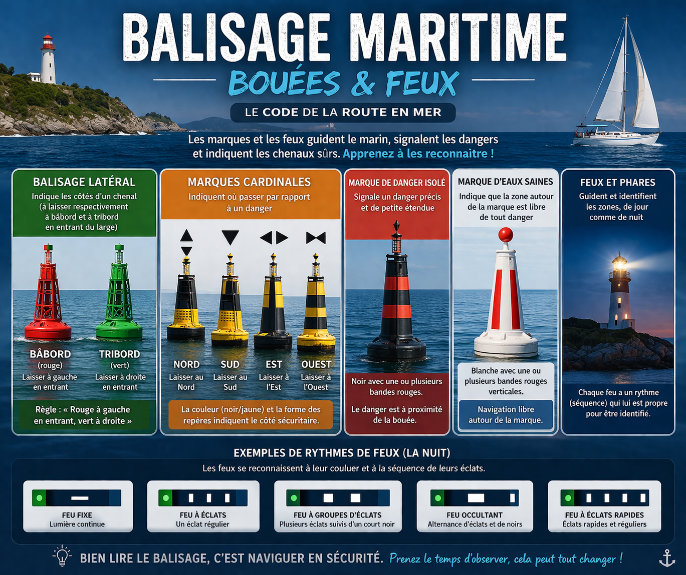
Lateral Marks: Following the Channel
Lateral marks define each side of a navigable channel. They indicate which side to pass on. In Region A (Europe):
Port-hand mark (left side when entering)
- Colour: red
- Shape: can (cylindrical)
- Topmark: red cylinder
- Light: red, flashing or isophase
- Leave to port (left) when travelling up-channel (entering harbour, in the direction of the flood stream)
Starboard-hand mark (right side when entering)
- Colour: green
- Shape: conical (cone pointing up)
- Topmark: green cone, point up
- Light: green, flashing or isophase
- Leave to starboard (right) when entering
A simple memory aid: in Region A, red to port on entry — the same side as you keep to when driving!
The marine chart integrated into YachtMate displays all lateral marks with their colour and light characteristics. Before entering an unfamiliar harbour, use the detailed view to quickly identify the channel and the buoys to watch for — even without an internet connection.
Cardinal Marks: Avoiding Hazards
Unlike lateral marks that define channels, cardinal marks indicate a specific hazard (rock, wreck, shoal) and show which side is safe to pass. Their name corresponds to the cardinal direction in which safe water lies.
All cardinal marks are yellow and black, but the arrangement of colours varies:
North Cardinal
- Colours: black above, yellow below
- Topmark: two black cones pointing up (↑↑)
- White light: very quick (VQ) or quick (Q) continuous flashes
- Pass to the north of the mark (it lies to the south of the hazard)
South Cardinal
- Colours: yellow above, black below
- Topmark: two black cones pointing down (↓↓)
- White light: 6 flashes + 1 long flash every 15 s
- Pass to the south of the mark
East Cardinal
- Colours: black-yellow-black (horizontal bands)
- Topmark: two cones, one up, one down (◇)
- White light: 3 quick flashes every 10 s
- Pass to the east of the mark
West Cardinal
- Colours: yellow-black-yellow (horizontal bands)
- Topmark: two cones pointing inward (⬡)
- White light: 9 quick flashes every 15 s
- Pass to the west of the mark
A handy trick for remembering the cardinal lights: think of a clock face. East = 3 flashes (3 o'clock), South = 6 flashes (6 o'clock), West = 9 flashes (9 o'clock), North = continuous flashes (12 o'clock/midnight).
Other Important Marks
Isolated Danger Mark
This buoy marks an isolated hazard surrounded by navigable water. It is black with red horizontal bands, with a topmark of two black spheres one above the other. Its white light always shows 2 grouped flashes. You may pass on any side, but keep a safe distance.
Safe Water Mark
Also called a mid-channel or fairway mark, it indicates navigable water all around. It is red and white vertically striped, with a red sphere topmark. Its white light is isophase, occulting, or shows 1 long flash. These are found at harbour entrances or the seaward end of a channel.
Special Mark
A yellow buoy indicates a special-purpose area: water sports zone, submarine cable, military area, nature reserve, mooring buoy field… It does not mark a navigation hazard but indicates something to be aware of. Its light, if any, is yellow.
Before anchoring, check for special marks in the area using YachtMate. The app overlays protected zones, submarine cables and anchoring restriction areas directly on the chart — a great tool for avoiding fines or damaging your anchor on submerged infrastructure.
Reading Light Characteristics
At night, fixed or floating buoys emit lights. Each light has a unique characteristic that allows it to be identified on the chart. Here are the main types:
- Fl (Flashing): flash — dark period is longer than the light
- Oc (Occulting): occultation — light dominates, interrupted by an eclipse
- Iso (Isophase): equal duration of light and dark
- Q (Quick): quick flashes (50–60/min)
- VQ (Very Quick): very quick flashes (100–120/min)
- LFl (Long Flash): long flash of at least 2 seconds
- Mo (Morse): Morse code signal (often the letter A)
On nautical charts, a light is described like this: Fl(3)G 10s — meaning 3 green flashes, period of 10 seconds. Practise reading these codes on charts before heading out to sea!
Luminous Range
Charts also show the range of lights in nautical miles. A coastal lighthouse may have a range of 20–30 miles, while a small channel buoy may only carry 3–5 miles. Nominal range is calculated for a visibility of 10 nautical miles — it will be reduced by fog or rain.
Mooring Buoys
In organised anchorage areas (marine protected areas, mooring zones), you'll find white buoys to tie up to. These are not navigation marks in the strict sense, but they follow a code:
- White buoy with blue band: paid or regulated mooring
- Orange buoy: often reserved for professionals or specific uses
- Buoy with ring or eyelet: take the buoy from above, pass a line through the eyelet
Always check the buoy's capacity (tonnage indicated) before tying up. A buoy rated for 5 tonnes is not suitable for a 12-tonne yacht.
YachtMate includes the AnchorFix feature, which alerts you if your boat drifts overnight at anchor. It automatically calculates your swing radius based on depth and chain length. No more keeping one eye open all night — sleep soundly!
Reading Nautical Charts
All marks and lights are shown on nautical charts (paper or digital). A few pointers for identifying them:
- Marks are shown as diamonds or circles, with their colour coded
- Light characteristics are noted in italics next to the mark
- Floating buoys have a wavy line under the symbol (they move with tides and currents)
- Fixed marks (channel beacons, towers, marked rocks) have an anchored symbol
- Colours on the chart don't always exactly match the real colours — refer to the legend
Get into the habit of planning your route in advance by identifying the main marks along your course. Note their light characteristics if you're sailing at night. This preparation takes 10 minutes and can save you from many surprises.
Practical Tips for Navigation
- Identify the conventional direction: in France, it generally follows the flood tide or the direction of approach to a harbour.
- Never approach a cardinal mark from its dangerous side: always pass on the side indicated by the cardinal name.
- At night, count the flashes: time the period and count the flashes to identify the mark.
- When in doubt, stop and check the chart: better to lose 5 minutes than to run aground on a shoal.
- Don't rely on memory alone: buoyage configurations change; buoys can disappear or be moved after a storm. Keep your charts up to date.
Maritime buoyage is a universal language that every sailor must master. With practice, reading a buoy or a light becomes as natural as reading a road sign. Take time to review these codes before every trip, and don't hesitate to practise at the dock by observing the buoys at harbour entrances.
Navigate with Marine Charts in YachtMate
YachtMate displays all marks, lights and navigation zones on an interactive chart available offline. Plan your route, identify channels and navigate with confidence — day and night.
Download YachtMate for free