The Mediterranean coast of France features some of the most famous and feared wind systems in the sailing world. Mistral, Tramontane, Marin, and lesser-known regional winds create distinct sailing conditions that have shaped maritime history for millennia. Understanding these winds—their origins, seasonal patterns, forecasting signs, and tactical responses—is essential for safe navigation in French waters. Legendary sailors from ancient Phoenicians to modern racers have studied these winds obsessively, as mastering them often determines the difference between a successful passage and a forced retreat to harbor. This guide explores the meteorology, safety implications, and practical tactics that enable sailors to navigate French coastal waters with confidence during wind events that can reach 50-70 knots and persist for days.
Mistral: The Legendary North Wind of Provence
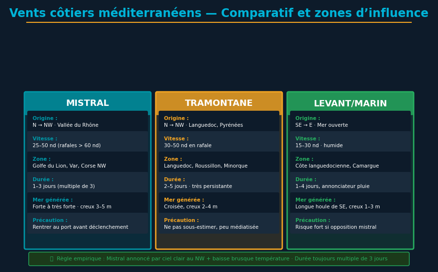
The Mistral is the most famous and most feared wind of the French Mediterranean. It originates from a massive funneling effect where the Rhône valley, lying between the Alps to the east and the Massif Central to the west, acts as a giant bellows. Cold, dense continental air mass accumulates over the interior of France and Switzerland. As atmospheric pressure differentials develop (typically 5-10 hPa pressure drop per 100 km between Paris and Marseille), this continental air accelerates downward through the narrow Rhône corridor toward the warm Mediterranean.
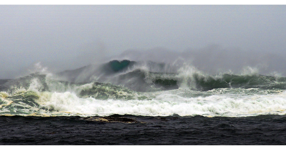
Typical Mistral characteristics: sustained winds 30-50 knots, gusts 60-90 knots, duration 3-9 consecutive days, peak intensity in late afternoon (solar heating amplifies pressure gradients), and seasonal frequency highest in winter (December-March) and spring (March-May). A mature Mistral event creates wave heights of 4-6 meters in the Golfe du Lion (Gulf of Lyon), with a short, steep wave period of 6-8 seconds—the worst combination for sailing comfort and safety.
The geographic impact area extends from the Rhône delta south to Corsica and Sardinia, and eastward across the entire Golfe du Lion. A typical Mistral track flows 300 km from coast, affecting sea lanes to Balearic Islands, Corsica, and Italy. The wind direction during Mistral averages 330-350 degrees (north to northwest), with a slight easterly component during the early and late phases.
Forecasting onset: barometric pressure gradient is the most reliable indicator. If pressure at Marseille-Provence (43°N, 5°E) is 5+ hPa lower than pressure at Paris (49°N, 2°E), a Mistral is almost certain within 12-24 hours. Modern Météo France "BMS" (Bulletin Météo Spécialisé) warns of Mistral onset 24-48 hours in advance. Additional warning signs include lenticular cloud formation over Alps (visible from coast), rapid increase of swell from southwest (preceeds wind by 6-12 hours), and clearing sky with excellent visibility (dry continental air displaces humid Mediterranean air).
Mistral Wave Formation and Sea State
The wave fetch (distance over which wind generates waves) in Golfe du Lion extends 300+ km from Rhône delta westward toward Spain. A 48-hour Mistral at 40 knots over this fetch generates significant wave height (Hs) of 4-5 meters, with maximum individual waves exceeding 8 meters. Wave period of 7-8 seconds creates steep, choppy seas—the worst conditions for sailboats, which perform better in longer-period swell.
Wave decay time after Mistral ceases is 24-36 hours. Even after wind drops to 5 knots, residual 3-4 meter swells persist, making harbor approaches challenging. Timing your harbor entry requires waiting not for wind to cease but for swell to subside below 2 meters.
Tramontane: The Northwest Wind of Languedoc
Tramontane is a similar funneling wind originating over the Pyrenees and flowing northeast toward the coast near Roussillon and Languedoc. Characteristics: slightly weaker than Mistral (typically 25-45 knots sustained, gusts 55-80 knots), duration 2-5 days, frequency highest spring and fall. Tramontane follows similar pressure pattern as Mistral (Paris to Roussillon pressure gradient > 4 hPa indicates Tramontane probability 80%+).
Tramontane tracks southeastward, affecting sea lanes from southwest France toward Balearic Islands and northern Spain. Wind direction during Tramontane averages 310-330 degrees, with greater variability than Mistral. Wave fetch shorter than Golfe du Lion (150-200 km maximum), resulting in wave heights 2-4 meters. This makes Tramontane slightly more manageable than Mistral for cruising sailors.
Marin and Other Regional Winds
Marin is a southeast wind bringing warm, humid air from the Mediterranean interior toward the Provence coast. Characteristics: less violent than Mistral (15-35 knots typical), direction 135-165 degrees (southeast to south), duration 12-48 hours, brings rain and poor visibility. Marin often precedes Mistral events—a transition wind lasting 6-12 hours before pressure gradient shifts, wind backs to north, and Mistral takes over.
Libeccio is a southwest wind affecting the Tyrrhenian Sea (between mainland Italy and Corsica/Sardinia). It rarely reaches the French coast directly but is important for sailors island-hopping to Corsica. Typical intensity 20-40 knots, duration 2-4 days.
Grec (also called Levante or Easterly) is an east wind funneling through the Bonifacio Strait (8 km gap between Corsica and Sardinia). The funneling effect creates amplified gusts of 30-50 knots despite moderate regional winds. Sailors transiting Bonifacio Strait must account for this amplification.
Ponant is a generic west wind with lower energy than Mistral. Typical intensity 10-25 knots, stable duration 2-3 days, brings clear skies. Regarded as favorable sailing wind by racers and cruisers.
Thermal Sea Breezes: Predictable Summer Afternoon Winds
During summer months (June-August), daily thermal cycles create predictable sea breeze patterns. Morning: offshore breeze 5-10 knots (cool air descending from mountains toward warm sea). Afternoon: onshore sea breeze 10-15 knots (warm sea air rising, cooler air from land rushing seaward to replace it). Evening: offshore breeze returns.
These thermal breeze cycles are so consistent that racers plan start times to coincide with peak afternoon sea breeze intensity (typically 1300-1600 hours local time). For cruisers, thermal breezes provide reliable wind for charging batteries (wind generator: 10 knots = 50W output, 15 knots = 200W) and confident short-distance passages.
Synoptic Forecasting: Reading Pressure Charts
Professional route forecasters study synoptic charts (atmospheric pressure maps) to predict wind patterns days in advance. A surface analysis chart shows high-pressure systems (anticyclones, marked "H") and low-pressure systems (depressions, marked "L"). Wind flows perpendicular to isobars (pressure contour lines), with velocity proportional to gradient (tightness) of isobars.
Mistral forecasting technique: examine 500 mb geopotential height chart (represents mid-atmosphere patterns). If a ridge of high pressure builds over Scandinavia and a trough (low pressure) deepens over the Atlantic, this pattern creates a pressure gradient across western Europe. Surface analysis will soon show this high-pressure system translating toward France, with southwesterly flow transitioning to northwesterly Mistral as the system moves east.
Time horizon: 500 mb patterns move roughly eastward at 15-20 degrees longitude per day. A pattern identified on Monday over the Atlantic will influence western Europe by Wednesday-Friday. This 4-5 day forecast window provides sufficient time for cruisers to plan passages or retreat to protected anchorage.
Modern Forecasting Tools: Apps and Web Services
Several specialized forecasting services provide marine-specific predictions superior to generic weather:
- Météo France Bulletins Marins (BMS): Official French maritime authority service, updated twice daily. BMS explicitly warns of Mistral/Tramontane onset 24-48 hours before. Cost: free. Website: meteofrance.com
- Windy (wind.today): Aggregates ECMWF, GFS, and AROME models. ECMWF provides most accurate medium-range (5-10 day) forecasts. Map overlay shows 24-hour wind forecasts with spatial resolution 9 km. Cost: free basic version, premium features 25 EUR/month. Real-time update frequency: 6 hours.
- PredictWind: Specialized marine routing service. Integrates high-resolution wind, current, and wave data. Provides "optimal routing" calculations that minimize passage time given vessel performance characteristics. Cost: 60-120 EUR per month subscription. Used by professional racers and serious cruisers.
- Meteo Consult Marine (consultation météorologique): French-language service, expert analysis of upcoming weather patterns. Provides hourly forecasts for specific locations (e.g., "Porquerolles harbor: 35 knots NW gusts 50" at specific times). Cost: 50-100 EUR per forecast. Especially valuable 24 hours before contested passages.
- Seafarer's Handbook GRIB data: GRIB (Gridded Binary) files provide machine-readable weather data compatible with navigation software (OpenCPN, Expedition, qtVlm). Download 5-10 day forecasts from NOAA or ECMWF and overlay on electronic charts. Cost: free. Requires understanding of map projection and data interpretation.
GRIB File Interpretation
A GRIB file contains multiple data layers: surface wind (u,v components), pressure, temperature, waves, precipitation. Layering these reveals patterns. If GRIB shows wind backing from SE (Marin) to N (Mistral) over a 12-hour period, combined with pressure falling 8 hPa in same window, Mistral onset is certain. The exact timing depends on pressure gradient—tight gradient = rapid wind increase (onset < 6 hours), loose gradient = slow increase (12-18 hours).
Safe Harbors: Anchoring Strategies by Wind Direction
French Mediterranean ports are strategically positioned to provide shelter from specific wind directions:
- Mistral (N-NW winds): Sheltered harbors on southern coasts. Porquerolles Island (southern tip, 43.0°N 6.2°E) provides excellent shelter in Mistral; anchorages along east side of island (Anse de la Courtade, d'Argent) protect from northwesterly. Giens Peninsula (43.0°N 6.4°E) offers similar shelter on east side. Port Grimaud (43.3°N 6.6°E) and Sainte-Tropez (43.3°N 6.6°E) in Varois coast provide harbor protection for Mistral, though outer roadstead is exposed.
- Tramontane (NW winds): Eastern Spanish coast and Balearic Islands are natural refuges, but impractical for French-based cruisers. Alternative: retreat to eastern coasts (Côte d'Azur, Monaco, La Spezia) where mountains block westerly wind. Port Lympia (Nice, 43.7°N 7.3°E) is well-sheltered.
- Marin/SE winds: Northern coasts of Var and Alpes-Maritimes (Porquerolles north side, Îles d'Hyères north side, Antibes harbor). Calanques of Marseille (43.2°N 5.3°E) provide deep-water anchorages protected from eastern winds by high limestone cliffs (150+ meter elevation).
The safest strategy: identify your position relative to known high-wind events 48 hours before onset, then transit toward shelter before wind strengthens. Waiting for wind to develop to 35+ knots then attempting passage to safe harbor is dangerous—by that time, seas are rough (4-6 meter waves), visibility is poor (spray, rain), and navigation becomes hazardous.
Tactical Sailing: Reefing and Risk Management
The cardinal rule: reef before you think you need to. A captain who reefs at first thought (15-knot wind showing signs of increasing) maintains control and safety. The captain who waits until wind is 25+ knots and seas are building takes unnecessary risk.
Reefing technique during Mistral: single-reef mainsail reduces area 40-50%, providing stable platform for subsequent maneuvers. With single-reef main and fully-furled jib (0% headsail), typical 35-foot cruiser reaches 6-8 knots true wind speed and maintains control even in 35-knot gusts. The key: a properly-reefed sail maintains aerodynamic efficiency, allowing responsive steering and controlled motion.
Risk escalation: if wind exceeds 45 knots despite reef main, deploy trysail (small triangular sail optimized for extreme conditions) and storm jib (1-2 square meters headsail). With trysail and storm jib, even a 40-footer becomes manageable in 50+ knot conditions. This rigging accepts reduced speed (3-4 knots) in exchange for control and safety.
The final option: heave-to (position boat at angle to wind, under balanced sail trim, allowing boat to drift slowly downwind while maintaining stability and control). A well-executed heave-to consumes minimal energy, allows crew rest, and positions the boat for recovery when wind subsides. Modern literature emphasizes that heave-to is not surrender but intelligent risk management.
Crossing to Corsica: Navigating Mistral Passages
The passage from mainland France to Corsica (50-80 nm depending on starting point) is exposed to Mistral during winter and spring. The standard route (Porquerolles to Bonifacio Strait) crosses the open Golfe du Lion where wave fetch creates largest swells.
Safe weather window: wait for high-pressure system positioned over France with northwesterly outflow but pressure gradient relaxing (wind dropping from 35+ to 20-25 knots). This transition period typically lasts 6-12 hours—sufficient time for a fast passage but insufficient for leisurely cruising.
Navigation technique: lay waypoint at Iles d'Hyères (north of route) for initial fix, then direct course to Bonifacio Strait (passing through Lavezzi Islands at 41.65°N 9.15°E). The total distance is 85-95 nm depending on starting point. At 6 knots average speed in strong wind conditions, passage requires 14-16 hours of continuous sailing—length justifying overnight passage planning and crew preparation.
Wave-riding technique: in beam seas (waves 90° to boat), optimize course 10-20° downwind of rhumb line to increase boat speed and reduce pitch motion. Modern performance cruisers can average 7-8 knots on this modified course even in 40-knot conditions, reducing passage time to 12-13 hours.
Beaufort Wind Scale: Understanding Wind Intensity
The Beaufort Wind Scale classifies wind intensity 0-12 (hurricane). For French Mediterranean operations:
Beaufort 5 (17-21 knots): Moderate breeze, moderate waves 4-8 feet, white foam crests. Typical summer afternoon breeze.
Beaufort 6 (22-27 knots): Strong breeze, large waves 10-13 feet, white foam everywhere. First reef indicated for most cruising boats.
Beaufort 7 (28-33 knots): Near gale, sea heaping 13-20 feet, white foam streaks. Double reef or trysail + storm jib recommended.
Beaufort 8 (34-40 knots): Gale, moderately high waves 13-20 feet but more developed, dense foam, sea beginning to roll. Third reef or trysail + storm jib mandatory. Most cruisers should seek shelter.
Beaufort 9+ (41+ knots): Strong gale and above, high waves 20+ feet, dense foam, sea tumbling. Heave-to or seek shelter essential. Passage planning should avoid these conditions.
Historical Mistral Events and Modern Forecasting Accuracy
The worst recorded Mistral occurred in January 1933, with sustained winds 65+ knots and wave heights exceeding 10 meters in Golfe du Lion. Modern pressure analysis indicates the pressure gradient (Paris to Marseille) exceeded 20 hPa—an extremely rare event. Modern forecasting would have provided 48-hour warning allowing all vessels to shelter.
Notable recent events include March 2010 "medicane" (Mediterranean hurricane-like low pressure), which merged Mistral outflow with warm-core Mediterranean depression, creating wind gusts 60+ knots and widespread marine incidents. Vessels at sea were largely unprepared due to miscommunication of forecast intensity. Subsequently, Météo France improved warning protocols.
Modern forecasting accuracy is exceptional: 48-hour wind forecast error typically ±3 knots (< 10% error for wind speed). 5-day error increases to ±8 knots but spatial patterns remain reliable. This means a sailor can confidently plan passages 3-4 days in advance knowing major wind patterns will align with forecast ±6-12 hours timing uncertainty.
Dangers of Underestimating Wind Forecast: Case Studies
Underestimation of high-wind forecasts has caused repeated marine incidents. In May 2005, a gust forecast of "40 knots" in Provençal waters was revised down to "30-35 knots expected, occasional gusts 45" by 1200 hours—after several yachts departed expecting 30-knot conditions. Actual wind: sustained 45+ knots, gusts 65+ knots by 1800 hours. Multiple yachts were caught under too much canvas; one sank after knockdown in 8-meter wave train.
Lesson: the phrase "occasional gusts 45" means that peak gusts will exceed sustained wind by 15-20 knots. A forecast of "sustained 30-35, gusts 45-50" actually predicts "wind 40-50 knots is likely under the worst gust; plan accordingly." Experienced sailors interpret forecasts conservatively: if forecast says "gusts 50 knots," assume sustained wind will reach 40 knots and plan reefing/passage decisions for 40 knots, not 30.
Conclusion: Respecting French Winds
Mistral, Tramontane, and related French Mediterranean winds are not mythological hazards but predictable meteorological systems. Understanding the synoptic patterns that generate these winds, consulting modern forecasting tools, identifying sheltered anchorages, and executing tactical sailing decisions enables safe navigation in even strong-wind events.
The sailors who thrive in French Mediterranean conditions are those who study forecasts 5-7 days in advance, plan passages to exploit favorable wind patterns, and unhesitatingly retreat to shelter when forecasts indicate dangerous conditions. Patience—waiting days for wind to swing or intensity to ease—is not weakness but wisdom. The Mediterranean will remain waiting after the Mistral passes; your boat and crew will be intact to enjoy it.
Master Mediterranean Weather
YachtMate integrates Météo France, ECMWF, and PredictWind forecasts with your GPS position, alerting you to Mistral onset 48 hours in advance.
Discover YachtMate →