Modern navigation at sea depends on an integrated suite of electronic instruments working in harmony. Gone are the days when sailors relied solely on paper charts and compass bearings. Today, a well-equipped cruising sailboat or powerboat typically features a GPS receiver, chartplotter, AIS transponder, VHF radio with DSC, depth sounder, wind instruments, and compass all networked via NMEA protocol. Understanding how these systems work together, their capabilities and limitations, and how to integrate them into a cohesive navigation strategy is essential for safe passage planning and decision-making in challenging conditions.
This comprehensive guide explores each major navigation instrument, how they communicate, their power and antenna requirements, practical installation considerations, and guidance on selecting appropriate equipment for different boat sizes and cruising profiles. Whether you're outfitting a 35-foot cruising yacht for ocean passages or upgrading a coastal day-cruiser, the principles and decision-making framework apply across all vessels.
GPS: The Foundation of Modern Navigation
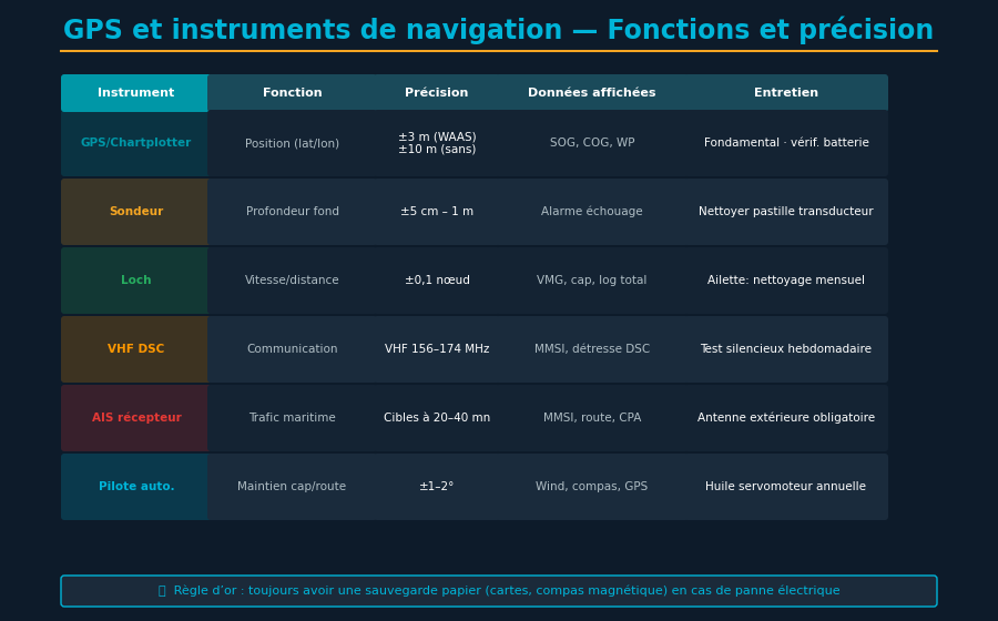
Global Positioning System receivers have revolutionized maritime navigation since becoming fully operational in 1995. A GPS receiver triangulates signals from at least four satellites to calculate precise position, speed, course over ground, and altitude. Modern civilian receivers achieve accuracy within 5 to 10 meters under good conditions, with altitude accuracy of 15 to 20 meters. This remarkable precision enables route planning with waypoints, collision avoidance, and automated navigation features impossible with traditional celestial or visual piloting methods.
How GPS Accuracy Works
GPS accuracy depends on several factors. Atmospheric conditions, particularly ionospheric delays, affect signal propagation time calculations. Multipath errors occur when signals bounce off water, hulls, or land features before reaching the receiver antenna, causing slight delays that reduce accuracy. Modern receivers employ statistical filtering and dead reckoning algorithms to smooth out these errors, providing position fixes every second (1 Hz) or faster (up to 10 Hz on high-end units).
Differential GPS (DGPS) and Real-Time Kinematic (RTK) systems can improve accuracy to within centimeters, but these require terrestrial base stations or satellite corrections (WAAS in North America, EGNOS in Europe) and are typically unnecessary for recreational boating. For navigation purposes, standard GPS accuracy of 5-10 meters is more than adequate for safe piloting.
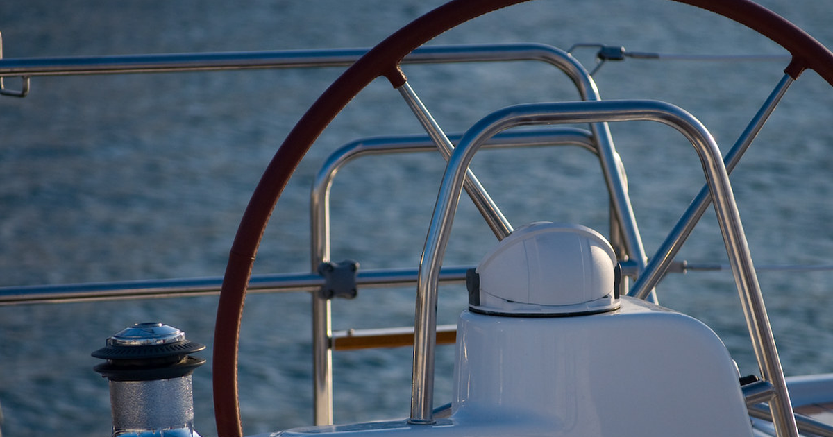
Always position your GPS antenna as high as possible and away from obstructions. A GPS antenna mounted on the mast (6 to 10 meters above water) will acquire satellites faster and maintain better lock in urban anchorages surrounded by tall buildings. Ensure the antenna cable is quality RG-58 or better, properly shielded, and kept away from high-current circuits and VHF antennas.
GPS Receivers and Chartplotters
Standalone GPS receivers display position, waypoints, and course information on small LCD screens, useful for recording tracks and navigation data but limited for comprehensive chart reference. Integrated chartplotters combine GPS receivers with electronic chart display systems (ECDIS), displaying your boat's position on detailed nautical charts. Major manufacturers like Garmin, Raymarine, Furuno, and Navico dominate the market with products ranging from $500 budget units to $5,000+ professional-grade systems.
When selecting a chartplotter, consider screen size (7-12 inches typical for cruising boats), processing speed, chart update frequency, and integration with other navigation instruments via NMEA 0183 or NMEA 2000 networking.
AIS: Automatic Identification System for Traffic Awareness
Automatic Identification System is a maritime automatic tracking system used by vessels and shore-based stations to identify and locate vessels. Every AIS transponder broadcasts the vessel's Maritime Mobile Service Identity (MMSI), position, course, speed, vessel dimensions, and destination every few seconds. Receiving AIS signals from nearby commercial vessels provides essential situational awareness, particularly in busy shipping lanes, at night, and in reduced visibility conditions.
Class A and Class B Transponders
Class A AIS transponders, mandated on large commercial vessels by international maritime law, broadcast with 12.5 watts power every 10 seconds (or less in close quarters). Class B transponders, designed for recreational vessels and smaller commercial ships, transmit with 2 watts power every 30 seconds, consuming less power and costing $400-$800. Both types receive signals from all vessels in range (typically 20-40 nautical miles in optimal conditions depending on antenna height). Some Class B systems use cellular networks to extend range far beyond radio horizon.
For cruising sailors, a Class B AIS transponder paired with a receive-only AIS receiver provides excellent collision avoidance capabilities. Receive-only units (passive AIS receiving stations) cost $200-$400 and display target vessels without broadcasting your position, a privacy option some cruisers prefer.
Integrate your AIS data with your chartplotter to display target vessels as symbols on the navigation screen. Set up collision avoidance alarms: if any vessel passes within your chosen safe passing distance (typically 1-2 nautical miles), the system alerts you. When navigating shipping lanes or in congested waters, actively monitor AIS targets and adjust course early rather than executing sharp maneuvers at the last moment.
VHF Radio and Digital Selective Calling
VHF (Very High Frequency) marine radio provides short-range two-way communication with other vessels and shore stations. Range is limited to line-of-sight, typically 15-25 nautical miles between vessels, up to 50+ miles when communicating with tall shore-based repeater stations. Channel 16 is the international distress frequency; Channel 9 is for commercial and port operations; Channels 13, 14, 70, and 72 are used for vessel-to-vessel communication in various regions.
Digital Selective Calling (DSC) enables automated distress alerting. A single button press broadcasts your MMSI, position (via GPS integration), and distress nature to all vessels and coast guard stations within range, dramatically improving rescue coordination compared to voice-only distress calls. Modern VHF radios with DSC integration are mandatory safety equipment for offshore passages and cost $300-$800 depending on features.
Fixed-Mount versus Handheld VHF
Fixed-mount VHF units with external antennas provide superior range (25 nautical miles minimum) and are essential for passages and blue-water cruising. Handheld VHF radios (with 1-5 watt power) provide backup communication with reduced range (5-10 nautical miles) and fit in a pocket. Many experienced cruisers carry both: a fixed unit for primary communication and a handheld for safety backup and dinghy communications.
Depth Sounders and Fish Finders
Depth sounders use sonar (sound navigation and ranging) to measure water depth by transmitting a sound pulse downward and measuring echo return time. They display instantaneous depth, water temperature, and bottom composition. Modern depth sounders function reliably in depths from 2 feet to over 1000 feet and cost $200-$1500 depending on transducer type and feature set.
Transducer Selection and Installation
Hull-mounted transducers are most common: a 20 kHz ceramic element provides high resolution in shallow to moderate depths (0-600 feet); dual-frequency transducers (typically 50/200 kHz) offer broad depth range with frequency-switching logic. Thru-hull transducers are mounted permanently through the hull; portable transom-mount units clamp to the transom for temporary use. Transducer placement matters significantly: position it where water flow is smooth (hull sides preferred, not directly behind the keel) and away from engine cooling water intakes.
A quality depth sounder is not a luxury—it's insurance. Unexpectedly shallow water has ended many cruises with grounded boats. Monitor bottom depth during approach to anchorages and unknown waters, and cross-check sounder readings with chart contours.
Wind Instruments: Apparent and True Wind
Wind instruments measure wind speed and direction relative to the boat (apparent wind) or relative to true geographic direction (true wind). Apparent wind is the combined effect of actual wind and the boat's motion through the air. For sailboat performance optimization and sail trim decisions, knowing both apparent wind (for immediate sail control) and true wind (for passage planning and strategic decisions) is invaluable.
Anemometers mounted at the masthead (mast-mounted sensors) avoid interference from sails and rigging, providing the cleanest wind data. Boat speed sensors (speed logs) combined with wind instruments and GPS allow the chartplotter to calculate true wind by vector subtraction. High-quality wind instrument systems from Garmin, Raymarine, or Navico range $800-$2500 installed.
NMEA Networking: Integration and Communication
NMEA 0183 is a serial communication standard enabling different navigation instruments to communicate instrument data. A GPS receiver broadcasts position data; the chartplotter receives it and displays boat position on the chart. The wind instrument sends wind data to the autopilot. The depth sounder sends depth data to the chartplotter for safety alerts. This integrated network vastly improves situational awareness and enables automation.
NMEA 0183 versus NMEA 2000
NMEA 0183 uses serial connections (RS-232) with point-to-point data flow; NMEA 2000 uses a CAN bus architecture enabling multiple devices to broadcast and receive simultaneously. NMEA 0183 installations are simpler and cheaper for small systems; NMEA 2000 scales better for complex systems with many sensors (wind, depth, temperature, fuel, voltage, etc.) and enables more sophisticated automation.
When planning a new navigation system, document all planned instruments and their data connections before purchasing. Ensure the primary chartplotter supports all required NMEA inputs. Test NMEA connections thoroughly before departing on a passage: a misconfigured NMEA network will cause cryptic navigation errors at sea when troubleshooting is most difficult.
Installation Checklist and Best Practices
Professional installation is strongly recommended for complex systems, but many cruisers successfully install simpler setups. Critical principles must be followed to ensure reliable operation in marine conditions:
- Cable protection: Protect all antenna cables with quality shielding; run power and signal cables separately, away from engine block, alternator, and high-current circuits
- Material selection: Use marine-grade stainless steel fasteners and corrosion-inhibiting compound on all connections
- Wire sizing: Ensure power cables are properly sized for current draw; undersized wiring causes voltage drop and equipment malfunction
- Documentation: Label all connections meticulously and maintain detailed documentation of system configuration
- Grounding: Ensure proper electrical grounding of all equipment to prevent electromagnetic interference
- Testing: Test every instrument before departing on a major passage
Power Consumption and Electrical Considerations
Modern navigation electronics are relatively power-efficient compared to older systems, but cumulative power draw matters on cruising boats with limited battery capacity. A typical navigation suite (GPS, chartplotter, VHF, depth sounder, wind instruments, autopilot) draws 15-40 watts continuously while the boat is underway. On long night passages, this sustained draw impacts battery voltage and can require increased engine running time or solar panel capacity.
Redundancy and Backup Power
Prudent cruisers employ redundancy: a backup handheld GPS, a paper chart and compass, a portable VHF radio. A battery backup system (Uninterruptible Power Supply) can keep critical instruments running for 30-60 minutes during an electrical failure, allowing safe anchoring or return to harbor. Fuse or circuit-protect each instrument on its own 15-amp circuit, preventing a single short circuit from disabling the entire navigation system.
Selecting Systems for Different Boat Types
Small Cruisers (25-32 feet)
A quality 7-inch chartplotter, external GPS/compass antenna, handheld VHF, depth sounder, and hand-held compass provide essential navigation capability at reasonable cost. Essential components for small cruisers include:
- 7-inch or smaller chartplotter with current chart database
- Integrated or standalone GPS receiver with backup handheld unit
- VHF radio with handheld as backup
- Depth sounder with transducer
- Paper charts and compass as backup navigation
- AIS receiver for traffic awareness in busy waters (optional but recommended)
Medium Cruisers (32-45 feet)
An integrated multi-function display (MFD) with high-quality charts, fixed-mount VHF with DSC, AIS Class B transponder, integrated wind/depth/temperature instruments via NMEA 2000, autopilot integration, and redundant GPS receivers support serious offshore cruising ($4000-$8000).
Larger Yachts (45+ feet)
Dual chartploters for navigational redundancy, integrated weather radar, high-end autopilots, comprehensive NMEA 2000 sensor arrays, professional-grade AIS Class A systems, and redundant power systems support extended offshore passages and professional operations ($8000-$25000+).
Conclusion: Mastering Electronic Navigation
Modern navigation instruments provide capabilities that would have seemed miraculous to sailors of previous generations. Yet these tools are servants, not masters. A prudent navigator understands his instruments' capabilities and limitations, maintains paper charts and compass skills, uses electronic systems to enhance situational awareness rather than replace judgment, and always has backup plans for electronic failures at sea. The integration of GPS, AIS, VHF, depth sounders, wind instruments, and chartplotters into a cohesive navigation system enables safer, more efficient passage making and is the defining characteristic of contemporary recreational and professional seamanship. Invest in quality equipment, install it thoughtfully, test it thoroughly, and develop genuine competence in its operation.
Navigate with Confidence
YachtMate integrates seamlessly with your navigation instruments via NMEA. Track conditions, plan routes, and share positions with crew in real time.
Discover YachtMate →