
Every summer, a single weather player largely decides what conditions you'll meet at sea, from Brittany to the Mediterranean: the Azores High. This vast field of high pressure, parked over the North Atlantic, governs the alternation of fine days and gales far more reliably than any single forecast. Understanding how it works, where it sits and how it evolves means you stop enduring the weather and start anticipating it. For the recreational sailor, learning to "read" this anticyclone lets you choose your departure window, estimate the strength and direction of the coming wind, and understand why a single week can swing from flat calm to a procession of depressions. This guide covers the essentials, without unnecessary jargon.
What is the Azores High?
An anticyclone is a zone of high atmospheric pressure — a region where the denser air slowly sinks toward the surface. This descending air warms and dries out, which dissolves clouds: that's why anticyclones are associated with stable fine weather, clear skies and generally light winds at the centre. The Azores High takes its name from the Portuguese archipelago around which it most often settles, off the Iberian and Moroccan coasts.
It isn't a fleeting phenomenon but a quasi-permanent structure of the Northern Hemisphere's atmospheric circulation. It exists all year round, but its influence over Europe shifts with the seasons. In summer it moves to higher latitudes and swells, extending its protective wing over southern Europe and much of the Atlantic. In winter it retreats south, clearing the way for the Atlantic depressions that then sweep our coasts. So it largely explains the contrast between the dry, sunny summers of the Mediterranean and the windy winters of the Bay of Biscay.
Remember the low/high contrast: in a depression, air rises, cools and condenses (cloud, rain, strong wind); in an anticyclone, air sinks, warms and dries (clear sky, light wind). Spotting the letters L and H on a chart tells you instantly which regime you'll be sailing in.
How the wind turns around an anticyclone
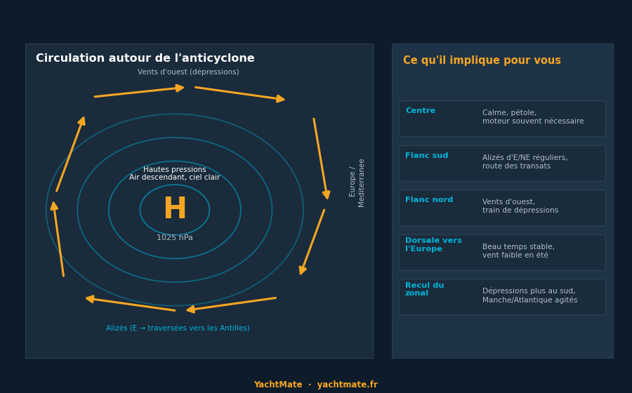
The wind doesn't blow "from" or "toward" the centre of an anticyclone: it turns around it, roughly following the isobars (lines of equal pressure). In the Northern Hemisphere this rotation is clockwise around high pressure. This has a major practical consequence: depending on whether you sail on the northern, southern, eastern or western flank of the high, you'll meet winds from very different directions.
Another essential rule: the tighter the isobars, the stronger the wind. At the core of the anticyclone the isobars are spread apart and the wind is light or even nil — the famous "doldrums" that often force you to motor. Moving away from the centre, the pressure gradient increases and the wind picks up. The diagram below sums up this circulation and what it means for your sailing.
The engine of fine weather in the Med and Atlantic
When the Azores High extends a ridge (a finger of high pressure) toward Western Europe, it installs the summer weather sailors know well. Clear skies, often smooth seas, moderate winds and steady thermals: these are ideal conditions for coastal cruising. In the Mediterranean, this anticyclonic influence explains the long stability of the summers, broken only by local wind regimes such as the mistral or tramontane when the setup allows.
But that stability has a downside for sailors: closest to the anticyclonic centre, the wind drops. Days of flat calm multiply, especially offshore and around midday before the sea breeze picks up along the coast. Reading the position of the high well lets you anticipate these windless spells — and plan fuel, patience, or an earlier start accordingly.
Trade winds and crossing routes
On the southern flank of the anticyclone blow the trade winds: easterly to north-easterly winds, remarkably steady in strength and direction. They are the ones that carry sailboats from the Canaries to the Caribbean, on the classic autumn and winter transatlantic route. The position and vigour of the Azores High directly condition the quality of these trades: a well-established, well-placed high guarantees sustained trades, while a weakened or distorted high makes them fickle.
That's why offshore navigators watch this anticyclone like a hawk: dropping far enough south to "hook" the trades, without sinking into the calms of the centre, is the whole art of crossing strategy. The routers' maxim — "sail south until the butter melts, then turn west" — expresses in its own way the geometry of the Azores High.
Even for a simple coastal cruise, knowing which side of the high you're on gives you the wind trend for the coming days. On the eastern flank (the French Atlantic seaboard), a rising high often shifts the wind to the north-west; on the southern flank, expect an easterly flow. It's a quick, free reading that complements the detailed forecast.
When the ridge collapses: the return of the depressions
The Azores High isn't static. It breathes, deforms, advances and retreats with the general circulation. When its ridge over Europe collapses or tilts south, it opens a breach: the Atlantic "storm track" then drops in latitude and comes to sweep the Channel, Brittany, the Bay of Biscay, even the north of the Iberian Peninsula. This is the typical scenario of a summer breakdown, where several fine days abruptly give way to wind, swell and rain.
For the sailor, these swings are the moments to watch closely. A high that "retreats" on the charts often heralds strengthening wind and a building sea within 24 to 72 hours. Conversely, a ridge that rebuilds signals a return to calm. Following the change in the high's position from one forecast to the next is often more telling than reading a single wind forecast in isolation.
"Don't just look at tomorrow's forecast wind: look at where the high is going. Its track tells you the whole week."
Reading the high on charts and GRIB files
In practice, where do you observe all this? On surface analysis and forecast charts, the anticyclone is identified by its letter H (or A on French charts) and its closed, concentric isobars, with the pressure value at the centre (often 1020 to 1030 hPa). GRIB files, loaded into routing apps, translate these pressure fields into wind arrows: you see directly the central calm zones and the windy areas on the periphery.
A few useful reading habits:
- Locate the H centre and note its pressure value: it's your reference point.
- Track its movement from one time step to the next: is it rising, dropping, stretching toward you or withdrawing?
- Look at the isobar spacing near your area: tight = strong wind, spread out = light wind.
- Position yourself relative to the centre to deduce the likely wind direction (clockwise rotation).
Always cross-check this "big picture" reading with coastal bulletins and local phenomena (sea breezes, headland effects, acceleration in straits). The high sets the backdrop; the terrain and coast paint the detail.
Before each outing, take thirty seconds to locate the Azores High on the forecast chart, then compare it with the day before. This simple habit transforms how you read the weather: you no longer endure a string of numbers, you understand the overall logic and anticipate the changes.
In summary
The Azores High is the discreet conductor of summer marine weather in Western Europe. A zone of high pressure and stable fine weather, it turns the wind clockwise around itself: steady trade winds on its southern flank, westerlies and depressions on its northern flank, calms at the centre. Its position and movements determine the alternation of fine days and gales, and shape both coastal cruising and the long crossing. By learning to spot it on a chart, to track its movements and to position your sailing relative to its centre, you gain a head start on the weather — and choose your windows instead of enduring them.
Anticipate the weather with YachtMate
Marine weather, charts, AIS and trip tracking: YachtMate brings together everything you need to prepare your outings with peace of mind. The app designed for recreational sailors, available on iOS and Android.
Discover YachtMate →